ទំព័រគំរូ:ប្រអប់ព័ត៌មាន ជម្លោះយោធា/doc
| This is a documentation subpage for ទំព័រគំរូ:ប្រអប់ព័ត៌មាន ជម្លោះយោធា. It may contain usage information, categories and other content that is not part of the original ទំព័រគំរូ page. |
Usage
កែប្រែMilitary conflict infobox
កែប្រែ| Battle of Lützen | |||||||
|---|---|---|---|---|---|---|---|
| ផ្នែកនៃthe Thirty Years' War | |||||||
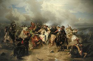
 The Battle of Lützen by Carl Wahlbom shows the death of King Gustavus Adolphus on November 16, 1632. | |||||||
| |||||||
| ភាគីសង្គ្រាម | |||||||
| Sweden, Protestant German states |
Holy Roman Empire, Catholic German states | ||||||
| មេបញ្ជាការ និង មេដឹកនាំ | |||||||
| Gustavus Adolphus †, Bernhard of Saxe-Weimar |
Albrecht von Wallenstein, Gottfried zu Pappenheim † | ||||||
| កម្លាំង | |||||||
| 12,800 infantry, 6,200 cavalry, 60 guns |
10,000 infantry, 7,000 cavalry, 24 guns | ||||||
| សហេតុភាព និង ការខាងបង់ | |||||||
| 3,400 dead, 1,600 wounded or missing |
3,000–3,500 dead or wounded | ||||||
A military conflict infobox (sometimes referred to as a warbox) may be used to summarize information about a particular military conflict (a battle, campaign, war, or group of related wars) in a standard manner.
The infobox should be added using the {{infobox military conflict}} template, as shown below:
{{infobox military conflict
| conflict    = First Cambodian-Siamese (1530-1531)
| partof      =
| image       =
| caption     =
| date        = 1530-1531 A.D
| place       = Cambodia
| coordinates =
| map_type    =
| latitude    =
| longitude   =
| map_size    =
| map_caption =
| map_label   =
| territory   =
| result      = Cambodian Victory
| status      =
| combatant1  =
| combatant2  =
| combatant3  =
| commander1  = Ang Chan I
| commander2  = Maha Chakkraphat
| commander3  =
| units1      =
| units2      =
| units3      =
| strength1   =
| strength2   =
| strength3   =
| casualties1 =
| casualties2 =
| casualties3 =
| notes       =
| campaignbox =

Microformat


កែប្រែ


The HTML mark up produced by this template includes an hCalendar microformat, which makes the event details parsable by computers, either acting automatically to catalogue article across Wikipedia, or via a browser tool operated by a person, to (for example) add the subject to a calendar or diary application. Within the hCalendar is a Geo microformat, which additionally makes the coordinates (latitude & longitude) parsable, so that they can be, say, looked up on a map, or downloaded to a GPS unit. For more information about the use of microformats on Wikipedia, please see the microformat project.

Dates will only be included if you use {{Start date}} or {{End date}} (use the former for single dates; (but do not use any of these if the date is before 1583 CE).

To include a URL, use {{URL}}.

hCalendar uses HTML classes including:

ទំព័រគំរូ:Flat list

Geo is produced by calling {{coord}}, and uses HTML classes:

ទំព័រគំរូ:Flat list

Please do not rename or remove these classes; nor collapse nested elements which use them.

When giving coordinates, please don't be overly precise.