ឯកសារ:Atlas Van der Hagen-KW1049B12 017-PORTUGALLIAE et ALGARBIAE REGNA.jpeg
ទំហំរបស់ការមើលមុននេះ: ៧២៤ × ៥៩៩ ភីកសែ។ ភាពម៉ត់ផ្សេងទៀត៖ ២៩០ × ២៤០ ភីកសែ | ៥៨០ × ៤៨០ ភីកសែ | ៩២៨ × ៧៦៨ ភីកសែ | ១២៣៧ × ១០២៤ ភីកសែ | ២៤៧៤ × ២០៤៨ ភីកសែ | ៥៥០០ × ៤៥៥៣ ភីកសែ។
រូបភាពដើម (៥៥០០ × ៤៥៥៣ ភីកសែល ទំហំឯកសារ៖ ៥.២១មេកាបៃ ប្រភេទ MIME៖ image/jpeg)
ចំណារពន្យល់
| Dirk Jansz van Santen: Atlas van Dirk van der Hagen (volledig, collectie KB)
|
||||||||||||||||||||||||||||||||||||||||||||||||||||
|---|---|---|---|---|---|---|---|---|---|---|---|---|---|---|---|---|---|---|---|---|---|---|---|---|---|---|---|---|---|---|---|---|---|---|---|---|---|---|---|---|---|---|---|---|---|---|---|---|---|---|---|---|
| វិចិត្រករ |
Author: Nicolaes Visscher II Publisher:
|
 | ||||||||||||||||||||||||||||||||||||||||||||||||||
| អ្នកនិពន្ធ |
Author: Nicolaes Visscher II Publisher:
|
|||||||||||||||||||||||||||||||||||||||||||||||||||
| ចំណងជើង |
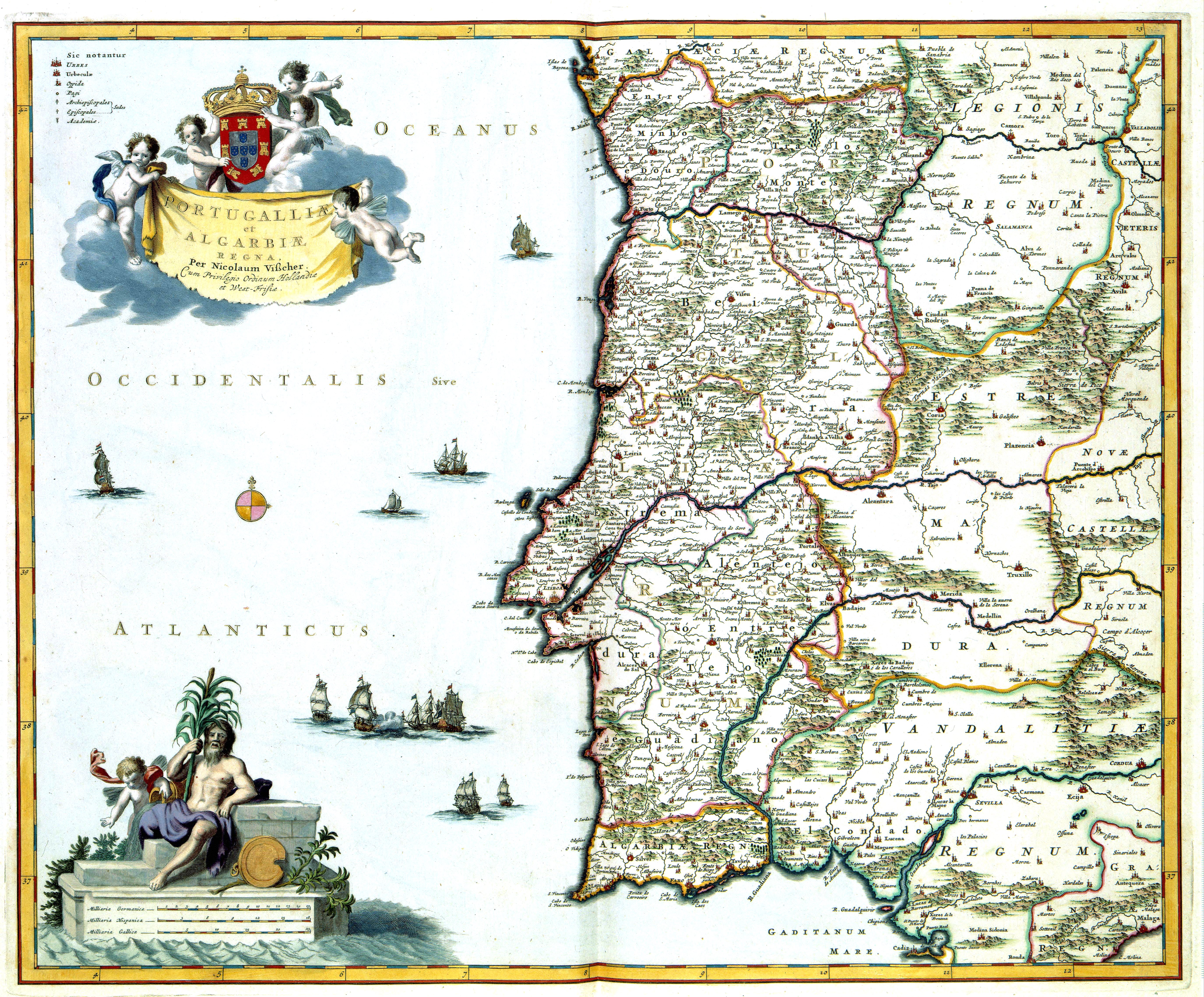
PORTUGALLIAE et ALGARBIAE REGNA |
|||||||||||||||||||||||||||||||||||||||||||||||||||
| Object type | map | |||||||||||||||||||||||||||||||||||||||||||||||||||
| ការពិពណ៌នា |
Nederlands: Deze kaart van Portugal werd in de tachtiger jaren van de 17de eeuw uitgegeven door Nicolaes Visscher II (1649-1702). Als bron gebruikte Visscher zeer waarschijnlijk een kaart van de Portugese kartograaf Pedro Texeira Albernaz (overleden 1662) die in 1662 een grote overzichtskaart van Portugal publiceerde. Zijn kaart vormde meer dan honderd jaar het prototype voor talrijke kaarten van het koninkrijk.
English: Map of Portugal, published in the eighties of the 17th century by Nicolaes Visscher II (1649-1702). It is probably based on a map of the cartographer Pedro Texeira Albernaz (died 1662), who published a general map of Portugal in 1662. His map was used more than a hundred years as a source for many maps of the kingdom. |
|||||||||||||||||||||||||||||||||||||||||||||||||||
| ភាសា |
ភាសាហូឡង់ |
|||||||||||||||||||||||||||||||||||||||||||||||||||
| កាលបរិច្ឆេទ | after ១៦៨១ | |||||||||||||||||||||||||||||||||||||||||||||||||||
| កាលបរិច្ឆេទបោះពុម្ពផ្សាយ |
circa |
|||||||||||||||||||||||||||||||||||||||||||||||||||
| មធ្យម |
Nederlands: kopergravure
English: copper engraving print |
|||||||||||||||||||||||||||||||||||||||||||||||||||
| វិមាត្រ | 47 x 56 cm | |||||||||||||||||||||||||||||||||||||||||||||||||||
| Collection |
|
|||||||||||||||||||||||||||||||||||||||||||||||||||
| អត្តលេខ |
Description of the Atlas Van der Hagen in the catalogue of the KB: http://opc4.kb.nl/DB=1/TTL=1/LNG=EN/PPN?PPN=353012750 |
|||||||||||||||||||||||||||||||||||||||||||||||||||
| Place of creation | Amsterdam | |||||||||||||||||||||||||||||||||||||||||||||||||||
| កំនត់ចំណាំ | KW1049B12_017 - Volume 1 | |||||||||||||||||||||||||||||||||||||||||||||||||||
| Related persons | Nicolaes Visscher II - Texeira Albernaz, Pedro | |||||||||||||||||||||||||||||||||||||||||||||||||||
| Depicted locations | Portugal - Algarve | |||||||||||||||||||||||||||||||||||||||||||||||||||
| ឯកសារយោង | ||||||||||||||||||||||||||||||||||||||||||||||||||||
| ប្រភព/ជាងថតរូប |
Source page at the Het Geheugen van Nederland/Memory of the Netherlands website.
|
|||||||||||||||||||||||||||||||||||||||||||||||||||
| ការអនុញ្ញាត (ប្រើឯកសារនេះឡើងវិញ) |
|
|||||||||||||||||||||||||||||||||||||||||||||||||||

ប្រវត្តិឯកសារ
ចុចលើម៉ោងនិងកាលបរិច្ឆេទដើម្បីមើលឯកសារដែលបានផ្ទុកឡើងនៅពេលនោះ។
| ម៉ោងនិងកាលបរិច្ឆេទ | កូនរូបភាព | វិមាត្រ | អ្នកប្រើប្រាស់ | យោបល់ | |
|---|---|---|---|---|---|
| បច្ចុប្បន្ន | ម៉ោង១២:២១ ថ្ងៃសុក្រ ទី០៩ ខែកុម្ភៈ ឆ្នាំ២០១៨ | | ៥៥០០ × ៤៥៥៣ (៥.២១មេកាបៃ) | Gryffindor | {{Information |Description= |Source= |Date= |Author= |Permission= |other_versions= }} |
| ម៉ោង០៩:៥០ ថ្ងៃសៅរ៍ ទី១៨ ខែកក្កដា ឆ្នាំ២០១៥ |  | ៥៥០០ × ៤៥៥៣ (៣.៦៨មេកាបៃ) | OlafJanssen | GWToolset: Creating mediafile for OlafJanssen. |
បម្រើបម្រាស់ឯកសារ
ទំព័រ ខាងក្រោមប្រើប្រាស់ឯកសារនេះ ៖
បម្រើបម្រាស់ឯកសារជាសាកល
វីគីដទៃទៀតដូចខាងក្រោមនេះប្រើប្រាស់ឯកសារនេះ៖
- ការប្រើប្រាស់នៅក្នុង ar.wikipedia.org
- ការប្រើប្រាស់នៅក្នុង en.wikipedia.org
- History of Portugal
- History of Portugal (1415–1578)
- Kingdom of Asturias
- Morisco
- Portuguese Empire
- Carnation Revolution
- Anglo-Portuguese Alliance
- Ophiussa
- Al-Andalus
- Estado Novo (Portugal)
- National Union (Portugal)
- Gallaecia
- Military history of Portugal
- Oestriminis
- Kingdom of Northern Lusitania
- Portuguese succession crisis of 1580
- Timeline of Portuguese history (Lusitania and Gallaecia)
- Timeline of Portuguese history (Second Dynasty)
- Timeline of Portuguese history (Fourth Dynasty)
- Timeline of Portuguese history (First Republic)
- Timeline of Portuguese history (Second Republic)
- Timeline of Portuguese history (Third Republic)
- Template:History of Portugal
- First Portuguese Republic
- User:Joaopais/To do
- History of Portugal (1640–1777)
- History of Portugal (1777–1834)
- History of Portugal (1834–1910)
- Ditadura Nacional
- Processo Revolucionário em Curso
- Economic history of Portugal
- Gharb al-Andalus
- National Salvation Junta
- Portugal during World War II
- Kingdom of Portugal
- Prehistoric Iberia
- County of Coimbra
- Third Portuguese Republic
- National Museum of Archaeology, Lisbon
- Patuleia
- Revolution of Maria da Fonte
- Emboscada (historical event)
- Regeneration (Portugal)
- Janeirinha
- Hispania
- Cristóvão Jacques
- Slavery in Portugal
- Portuguese Cortes
- Social and cultural exchange in al-Andalus
View more global usage of this file.