ឯកសារ:Borneo2 map english names.PNG

ទំហំរបស់ការមើលមុននេះ: ៥៣៩ × ៦០០ ភីកសែ។ ភាពម៉ត់ផ្សេងទៀត៖ ២១៦ × ២៤០ ភីកសែ | ៤៣១ × ៤៨០ ភីកសែ | ៦៩០ × ៧៦៨ ភីកសែ | ១០៦៣ × ១១៨៣ ភីកសែ។
រូបភាពដើម (១០៦៣ × ១១៨៣ ភីកសែល ទំហំឯកសារ៖ ២៣៦គីឡូបៃ ប្រភេទ MIME៖ image/png)
ចំណារពន្យល់
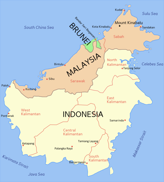
(English) Political map of Borneo, based on information from several maps.
- Light yellow = Indonesia
- Light orange = Malaysia
- Green = Brunei
For a blank political map see Image:Borneo blank map.PNG
(Bahasa Melayu) Peta Borneo, berdasarkan maklumat dari beberapa peta berlainan.
- Kuning cair = Indonesia
- Oren cair = Malaysia
- Hijau = Brunei
Untuk melihat peta Borneo kosong, sila ke Image:Borneo blank map.PNG

|
File:Borneo2 map english names.svg is a vector version of this file. It should be used in place of this PNG file when not inferior.
File:Borneo2 map english names.PNG → File:Borneo2 map english names.svg
For more information, see Help:SVG. |
 |
ការដាក់អាជ្ញាប័ណ្ណ

|
រូបភាពនៃទំព័រនេះជាកម្មសិទ្ធិរបស់GNU Free Documentation License។ Version 1.2 ឬក៏ខ្ពស់ជាងនេះត្រូវបានឧបត្ថមគាំទ្រដោយ មូលនិធិសូហ្វវែរដោយឥតគិតថ្លៃ (Free Software Foundation) ដែលមិនមានផ្នែកណាមួយរបស់ប្រភពដើមរួមទាំងអក្សរនៅលើគំរបមុខនិងខ្នង ត្រូវបានផ្លាស់ប្តូរទេ។ ចំពោះផ្នែកដែលមិនអាចផ្លាស់ប្តូរបាន សូមមើលGNU Free Documentation License។ |
| ឯកសារនេះជាប់អាជ្ញាបណ្ឌCreative Commons Attribution-Share Alike 3.0 Unported។ | ||
| ||
| This licensing tag was added to this file as part of the GFDL licensing update. |
ប្រវត្តិឯកសារ
ចុចលើម៉ោងនិងកាលបរិច្ឆេទដើម្បីមើលឯកសារដែលបានផ្ទុកឡើងនៅពេលនោះ។
| ម៉ោងនិងកាលបរិច្ឆេទ | កូនរូបភាព | វិមាត្រ | អ្នកប្រើប្រាស់ | យោបល់ | |
|---|---|---|---|---|---|
| បច្ចុប្បន្ន | ម៉ោង១៥:៥៤ ថ្ងៃអង្គារ ទី៣០ ខែតុលា ឆ្នាំ២០១២ | | ១០៦៣ × ១១៨៣ (២៣៦គីឡូបៃ) | Exagren | revision, +North Kalimantan |
| ម៉ោង១២:៤៩ ថ្ងៃសៅរ៍ ទី២៤ ខែមិថុនា ឆ្នាំ២០០៦ |  | ១០៦៣ × ១១៨៣ (៧៣គីឡូបៃ) | Roke~commonswiki | blue text labels on ocean | |
| ម៉ោង១០:៤១ ថ្ងៃច័ន្ទ ទី២០ ខែកុម្ភៈ ឆ្នាំ២០០៦ |  | ១០៦៣ × ១១៨៣ (៦៩គីឡូបៃ) | Roke~commonswiki | Map of Borneo, based on information from several maps. *Light yellow = Indonesia *Light Orange = Malaysia *Green = Brunei For a blank map see Image:Borneo blank map.PNG Category: Indonesia Category: Malaysia Category: Brunei |
បម្រើបម្រាស់ឯកសារ
គ្មានទំព័រណាមួយដែលប្រើប្រាស់ឯកសារនេះទេ។
បម្រើបម្រាស់ឯកសារជាសាកល
វីគីដទៃទៀតដូចខាងក្រោមនេះប្រើប្រាស់ឯកសារនេះ៖
- ការប្រើប្រាស់នៅក្នុង ar.wikipedia.org
- ការប្រើប្រាស់នៅក្នុង bcl.wikipedia.org
- ការប្រើប្រាស់នៅក្នុង br.wikipedia.org
- ការប្រើប្រាស់នៅក្នុង ca.wikipedia.org
- ការប្រើប្រាស់នៅក្នុង ceb.wikipedia.org
- ការប្រើប្រាស់នៅក្នុង ckb.wikipedia.org
- ការប្រើប្រាស់នៅក្នុង cs.wikipedia.org
- ការប្រើប្រាស់នៅក្នុង cy.wikipedia.org
- ការប្រើប្រាស់នៅក្នុង da.wikipedia.org
- ការប្រើប្រាស់នៅក្នុង en.wikipedia.org
- ការប្រើប្រាស់នៅក្នុង fi.wikipedia.org
- ការប្រើប្រាស់នៅក្នុង frr.wikipedia.org
- ការប្រើប្រាស់នៅក្នុង fr.wikipedia.org
- ការប្រើប្រាស់នៅក្នុង fr.wikinews.org
- ការប្រើប្រាស់នៅក្នុង gd.wikipedia.org
- ការប្រើប្រាស់នៅក្នុង he.wikipedia.org
- ការប្រើប្រាស់នៅក្នុង id.wikipedia.org
- ការប្រើប្រាស់នៅក្នុង ja.wikipedia.org
- ការប្រើប្រាស់នៅក្នុង jv.wikipedia.org
- ការប្រើប្រាស់នៅក្នុង la.wikipedia.org
- ការប្រើប្រាស់នៅក្នុង map-bms.wikipedia.org
- ការប្រើប្រាស់នៅក្នុង min.wikipedia.org
- ការប្រើប្រាស់នៅក្នុង mr.wikipedia.org
- ការប្រើប្រាស់នៅក្នុង ms.wikipedia.org
- ការប្រើប្រាស់នៅក្នុង nl.wikipedia.org
- ការប្រើប្រាស់នៅក្នុង nn.wikipedia.org
- ការប្រើប្រាស់នៅក្នុង no.wikipedia.org
- ការប្រើប្រាស់នៅក្នុង pam.wikipedia.org
- ការប្រើប្រាស់នៅក្នុង pl.wikipedia.org
- ការប្រើប្រាស់នៅក្នុង pt.wikipedia.org
- ការប្រើប្រាស់នៅក្នុង scn.wikipedia.org
- ការប្រើប្រាស់នៅក្នុង sk.wikipedia.org
- ការប្រើប្រាស់នៅក្នុង sv.wikipedia.org
- ការប្រើប្រាស់នៅក្នុង ta.wikipedia.org
- ការប្រើប្រាស់នៅក្នុង ta.wikinews.org
- ការប្រើប្រាស់នៅក្នុង tg.wikipedia.org
- ការប្រើប្រាស់នៅក្នុង tl.wikipedia.org
- ការប្រើប្រាស់នៅក្នុង tr.wiktionary.org
View more global usage of this file.