ឯកសារ:Burmese-Siamese war (1765-1767) map - EN - 001.jpg

ទំហំរបស់ការមើលមុននេះ: ៣៤២ × ៥៩៩ ភីកសែ។ ភាពម៉ត់ផ្សេងទៀត៖ ១៣៧ × ២៤០ ភីកសែ | ២៧៤ × ៤៨០ ភីកសែ | ៤៣៨ × ៧៦៨ ភីកសែ | ៥៨៤ × ១០២៤ ភីកសែ | ១៥១៦ × ២៦៥៧ ភីកសែ។
រូបភាពដើម (១៥១៦ × ២៦៥៧ ភីកសែល ទំហំឯកសារ៖ ៤៦១គីឡូបៃ ប្រភេទ MIME៖ image/jpeg)
ចំណារពន្យល់
| ការពិពណ៌នា |
English:
ไทย:
|
| កាលបរិច្ឆេទ | |
| ប្រភព |
ការងារផ្ទាល់របស់អ្នកផ្ទុកឡើង
Terwiel, Bertrand. Thailand's Political History: From the 13th Century to Recent Times. Approximate boundaries of the six states that formed after Ayutthaya's destruction. |
| អ្នកនិពន្ធ | Aristitleism |
| ទំរង់ផ្សេងទៀត |
_map_-_TH_-_002.jpg) |
ការដាក់អាជ្ញាប័ណ្ណ
I, the copyright holder of this work, hereby publish it under the following license:
| This file is made available under the Creative Commons CC0 1.0 Universal Public Domain Dedication. | |
| The person who associated a work with this deed has dedicated the work to the public domain by waiving all of their rights to the work worldwide under copyright law, including all related and neighboring rights, to the extent allowed by law. You can copy, modify, distribute and perform the work, even for commercial purposes, all without asking permission.
|
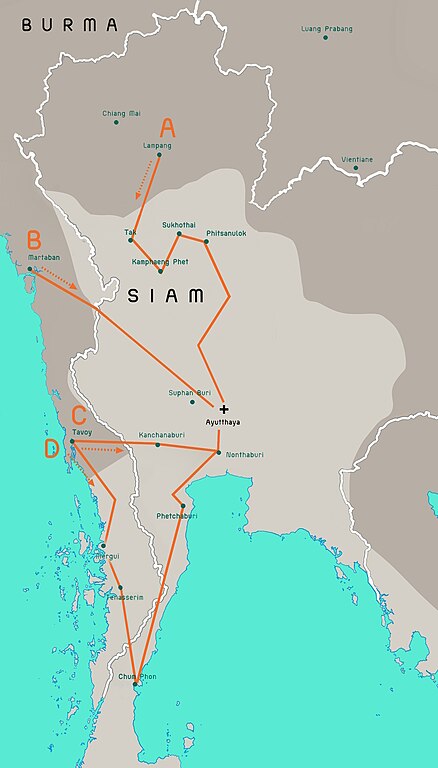
en:Burmese–Siamese War (1765–1767)

|
រូបភាព historical mapនេះ គួរតែបង្កើតឡើងវិញដោយប្រើក្រាភិកវ៉ិចទ័រ ដែលជាប្រភេទហ្វាល់ SVG ។ ការបង្កើតរូបភាពជាហ្វាល់ SVG ផ្តល់នូវអត្ថប្រយោជន៍ជាច្រើន។ ចំពោះព័ត៌មានបន្ថែម សូមមើល Commons:Media for cleanup ។ ប្រសិនបើទំរង់ SVG នៃរូបភាពនេះត្រូវបានបង្កើតរួចរាល់ហើយ សូមអាប់ឡូដវា។ បន្ទាប់ពីអាប់ឡូដជាទំរង់ SVG សូមជំនួសទំព័រគំរូនេះដោយ {{vector version available|ឈ្មោះរូបភាពថ្មី.svg}} ។
|


_map_-_EN_-_001.jpg)
ប្រវត្តិឯកសារ
ចុចលើម៉ោងនិងកាលបរិច្ឆេទដើម្បីមើលឯកសារដែលបានផ្ទុកឡើងនៅពេលនោះ។
_map_-_EN_-_001.jpg&dir=prev)
_map_-_EN_-_001.jpg&offset=20110724171301)
_map_-_EN_-_001.jpg&offset=&limit=20)
_map_-_EN_-_001.jpg&offset=&limit=50)
_map_-_EN_-_001.jpg&offset=&limit=100)
_map_-_EN_-_001.jpg&offset=&limit=250)
_map_-_EN_-_001.jpg&offset=&limit=500)
| ម៉ោងនិងកាលបរិច្ឆេទ | កូនរូបភាព | វិមាត្រ | អ្នកប្រើប្រាស់ | យោបល់ | |
|---|---|---|---|---|---|
| បច្ចុប្បន្ន | ម៉ោង០៨:២៩ ថ្ងៃពុធ ទី១៩ ខែកក្កដា ឆ្នាំ២០២៣ | | ១៥១៦ × ២៦៥៧ (៤៦១គីឡូបៃ) | Yourlocallordandsavior | Based off the Siamese civil war borders from Terwiel's "Thailand's Political History: From the 13th Century to Recent Times". |
| ម៉ោង០៨:៥១ ថ្ងៃពុធ ទី១២ ខែកក្កដា ឆ្នាំ២០២៣ |  | ១៥១៦ × ២៦៥៧ (៤៦៤គីឡូបៃ) | Yourlocallordandsavior | Major updated borders (riverine and land). | |
| ម៉ោង០៣:៤០ ថ្ងៃសុក្រ ទី០៣ ខែមីនា ឆ្នាំ២០២៣ |  | ១៥១៦ × ២៦៥៧ (៤០២គីឡូបៃ) | Yourlocallordandsavior | Added Phetchabun according to 17th century urban places map in "A History of Ayutthaya" by Baker and Phongpaichit. | |
| ម៉ោង០៤:៤៥ ថ្ងៃអាទិត្យ ទី១៩ ខែកុម្ភៈ ឆ្នាំ២០២៣ |  | ១៥១៦ × ២៦៥៧ (៤០៣គីឡូបៃ) | Yourlocallordandsavior | Added Phimai, Phimai was where Prince Thepphiphit had his seat of power in the 1767-71 civil war. | |
| ម៉ោង០២:៤៦ ថ្ងៃអាទិត្យ ទី១៩ ខែកុម្ភៈ ឆ្នាំ២០២៣ |  | ១៥១៦ × ២៦៥៧ (៤០៤គីឡូបៃ) | Yourlocallordandsavior | . | |
| ម៉ោង០១:២៧ ថ្ងៃអាទិត្យ ទី១៩ ខែកុម្ភៈ ឆ្នាំ២០២៣ |  | ១៥១៦ × ២៦៥៧ (៤០៦គីឡូបៃ) | Yourlocallordandsavior | Removed the Forest Mueang and adjusted borders. | |
| ម៉ោង១៧:២៣ ថ្ងៃសុក្រ ទី១៩ ខែសីហា ឆ្នាំ២០១១ |  | ១៥១៦ × ២៦៥៧ (១.០៥មេកាបៃ) | Tiemianwusi | Changing the colour of the third territories (from pale blue to pale taupe) | |
| ម៉ោង១៥:៤៧ ថ្ងៃសុក្រ ទី១៩ ខែសីហា ឆ្នាំ២០១១ |  | ១៥១៦ × ២៦៥៧ (១.០៥មេកាបៃ) | Tiemianwusi | (1) Correcting boundaries, (2) Darker Burmese territories, (3) Recolouring third territories, (4) Correcting advance routes. | |
| ម៉ោង០៨:៤៧ ថ្ងៃច័ន្ទ ទី២៥ ខែកក្កដា ឆ្នាំ២០១១ |  | ១៥១៦ × ២៦៥៧ (១.០៥មេកាបៃ) | Tiemianwusi | "Margui" → "Mergui" | |
| ម៉ោង១៧:១៣ ថ្ងៃអាទិត្យ ទី២៤ ខែកក្កដា ឆ្នាំ២០១១ |  | ១៥១៦ × ២៦៥៧ (១.០៥មេកាបៃ) | Tiemianwusi | Correcting territories |
បម្រើបម្រាស់ឯកសារ
ទំព័រ ខាងក្រោមប្រើប្រាស់ឯកសារនេះ ៖
បម្រើបម្រាស់ឯកសារជាសាកល
វីគីដទៃទៀតដូចខាងក្រោមនេះប្រើប្រាស់ឯកសារនេះ៖
- ការប្រើប្រាស់នៅក្នុង ar.wikipedia.org
- ការប្រើប្រាស់នៅក្នុង en.wikipedia.org
- ការប្រើប្រាស់នៅក្នុង es.wikipedia.org
- ការប្រើប្រាស់នៅក្នុង it.wikipedia.org
- ការប្រើប្រាស់នៅក្នុង my.wikipedia.org
- ការប្រើប្រាស់នៅក្នុង uk.wikipedia.org
- ការប្រើប្រាស់នៅក្នុង vi.wikipedia.org
- ការប្រើប្រាស់នៅក្នុង www.wikidata.org
- ការប្រើប្រាស់នៅក្នុង zh.wikipedia.org
_map_-_EN_-_001.jpg)