ឯកសារ:Central America (orthographic projection).svg

Size of this PNG preview of this SVG file: ៥៥០ × ៥៥០ ភីកសែ. ភាពម៉ត់ផ្សេងទៀត៖ ២៤០ × ២៤០ ភីកសែ | ៤៨០ × ៤៨០ ភីកសែ | ៧៦៨ × ៧៦៨ ភីកសែ | ១០២៤ × ១០២៤ ភីកសែ | ២០៤៨ × ២០៤៨ ភីកសែ។
រូបភាពដើម (ឯកសារប្រភេទSVG ៥៥០ × ៥៥០ ភីកសែល ទំហំឯកសារ៖ ៣៥៤គីឡូបៃ)
ចំណារពន្យល់
| ការពិពណ៌នា |
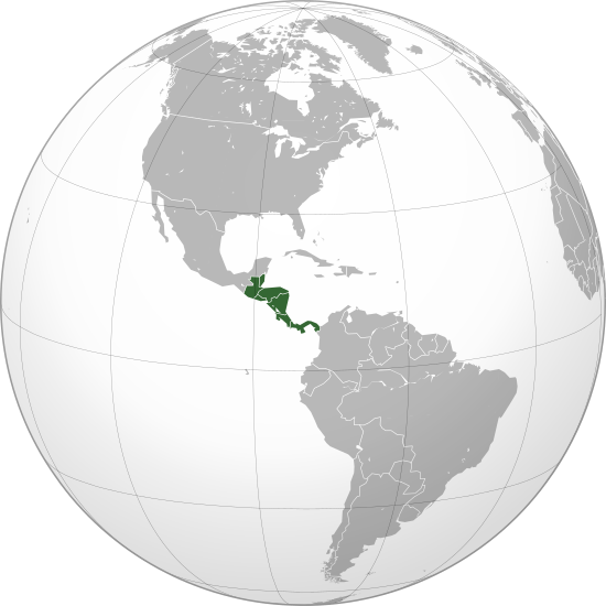
English: Central America (orthographic projection) with colonial borders |
||||
| កាលបរិច្ឆេទ | |||||
| ប្រភព |
ការងារផ្ទាល់របស់អ្នកផ្ទុកឡើង (Original text: Own work,)
|
||||
| អ្នកនិពន្ធ | Heraldry | ||||
| ការអនុញ្ញាត (ប្រើឯកសារនេះឡើងវិញ) |
|
||||
| ទំរង់ផ្សេងទៀត |
.svg) |
||||
| SVG genesis | រូបភាពក្រាភិកវ៉ិចទ័រនេះត្រូវបានបង្កើតឡើងដោយប្រើ Inkscape. |

.svg)
.svg)
.svg)
.svg)
.svg)
.svg)
.svg)
.svg)
.svg)
.svg)
.svg)
.svg)
.svg)
.svg)
.svg)
.svg)
.svg)
.svg)
.svg)
.svg)
.svg)
.svg)
.svg)
.svg)
.svg)
.svg)
.svg)
.svg)
.svg)
.svg)
.svg)
.svg)
.svg)
.svg)
.svg)
.svg)
.svg)
.svg)
.svg)
.svg)
.svg)
.svg)
.svg)
.svg)
.svg)
.svg)
.svg)
.svg)
.svg)
.svg)
.svg)
.svg)
.svg)
.svg)
.svg)
.svg)
.svg)
.svg)
.svg)
.svg)
.svg)
.svg)
.svg)
.svg)
.svg)
.svg)
.svg)
.svg)
.svg)
.svg)
.svg)
.svg)
.svg)

.svg)

.svg)

.svg)
.svg)
.svg)
.svg)
.svg)
.svg)
.svg)


.svg)
.svg)
.svg)
.svg)
.svg)
.svg)
.svg)

.svg)
.svg)
.svg)
.svg)
.svg)
.svg)
.svg)
.svg)
.svg)

.svg)
.svg)
.svg)
.svg)
.svg)
.svg)
.svg)
_without_national_boundaries.svg)
.svg)
.svg)
.svg)
.svg)
.svg)
.svg)

.svg)
.svg)
.png)
.svg)
.svg)
.svg)
.svg)

.svg)
.svg)
.svg)
.svg)
.svg)
.svg)
.svg)
.svg)
.svg)
.svg)
.svg)

.svg)
.svg)
.svg)
.svg)
.svg)
.svg)
.svg)
.svg)
.svg)

.svg)
.svg)

.svg)
.svg)
.svg)
.svg)
.svg)
.svg)
.svg)
.svg)
.svg)
.svg)
.svg)
.svg)
.svg)
.svg)
.svg)
.svg)
.svg)
.svg)
.svg)
.svg)
.svg)
.svg)
.svg)
.svg)
.svg)
.svg)
.svg)
_-_Crimea_disputed.svg)
.svg)
.svg)
.svg)
.svg)
.svg)
.svg)
.svg)
.svg)
.svg)
.svg)
.svg)
_political.svg)
.svg)
.svg)
.svg)
.svg)
_-_Crimea_disputed_-_no_borders.svg)
.svg)
.svg)
.svg)
.svg)
.svg)
.svg)
.svg)
.svg)
.svg)
.svg)
.svg)

.svg)
.svg)
.svg)

.png)
.svg)
.svg)
.svg)
.svg)
.svg)
.svg)
.svg)
.svg)
.svg)
.svg)
.svg)
.svg)
.svg)
.svg)
.svg)
.svg)
.svg)
.svg)
.svg)
.svg)
.svg)
.svg)
.svg)
.svg)
.svg)
.svg)
.svg)
.svg)
.svg)
.svg)
.svg)
.svg)
.svg)
.svg)
.png)
.svg)
.svg)
.svg)
_(orthographic_projection).png)
.svg)
.svg)
.svg)
.svg)
.svg)
ការដាក់អាជ្ញាប័ណ្ណ
I, the copyright holder of this work, hereby publish it under the following license:

|
រូបភាពនៃទំព័រនេះជាកម្មសិទ្ធិរបស់GNU Free Documentation License។ Version 1.2 ឬក៏ខ្ពស់ជាងនេះត្រូវបានឧបត្ថមគាំទ្រដោយ មូលនិធិសូហ្វវែរដោយឥតគិតថ្លៃ (Free Software Foundation) ដែលមិនមានផ្នែកណាមួយរបស់ប្រភពដើមរួមទាំងអក្សរនៅលើគំរបមុខនិងខ្នង ត្រូវបានផ្លាស់ប្តូរទេ។ ចំពោះផ្នែកដែលមិនអាចផ្លាស់ប្តូរបាន សូមមើលGNU Free Documentation License។ |
| ឯកសារនេះជាប់អាជ្ញាបណ្ឌCreative Commons Attribution-Share Alike 3.0 Unported។ | ||
| ||
| This licensing tag was added to this file as part of the GFDL licensing update. |
ប្រវត្តិឯកសារ
ចុចលើម៉ោងនិងកាលបរិច្ឆេទដើម្បីមើលឯកសារដែលបានផ្ទុកឡើងនៅពេលនោះ។
.svg&dir=prev)
.svg&offset=20090710081847)
.svg&offset=&limit=20)
.svg&offset=&limit=50)
.svg&offset=&limit=100)
.svg&offset=&limit=250)
.svg&offset=&limit=500)
| ម៉ោងនិងកាលបរិច្ឆេទ | កូនរូបភាព | វិមាត្រ | អ្នកប្រើប្រាស់ | យោបល់ | |
|---|---|---|---|---|---|
| បច្ចុប្បន្ន | ម៉ោង០២:០១ ថ្ងៃព្រហស្បតិ៍ ទី២៩ ខែមិថុនា ឆ្នាំ២០២៣ | | ៥៥០ × ៥៥០ (៣៥៤គីឡូបៃ) | Avaflyne | Reverted to version as of 05:29, 26 June 2023 (UTC) |
| ម៉ោង១៤:១៥ ថ្ងៃច័ន្ទ ទី២៦ ខែមិថុនា ឆ្នាំ២០២៣ |  | ២០៤៨ × ២០៤៨ (៣៩១គីឡូបៃ) | HelpfulHens | Mexico is part of Central America according the the United Nations | |
| ម៉ោង០៥:២៩ ថ្ងៃច័ន្ទ ទី២៦ ខែមិថុនា ឆ្នាំ២០២៣ |  | ៥៥០ × ៥៥០ (៣៥៤គីឡូបៃ) | Treetoes023 | Reverted to version as of 15:04, 25 November 2009 (UTC) | |
| ម៉ោង២០:៣១ ថ្ងៃអាទិត្យ ទី២៥ ខែមិថុនា ឆ្នាំ២០២៣ |  | ២០៤៨ × ២០៤៨ (៣៩១គីឡូបៃ) | HelpfulHens | Removed Colombia and Venezuela | |
| ម៉ោង១៣:១១ ថ្ងៃច័ន្ទ ទី១៣ ខែមីនា ឆ្នាំ២០២៣ |  | ៥៥០ × ៥៥០ (៣៥៤គីឡូបៃ) | LR0725 | Reverted to version as of 15:04, 25 November 2009 (UTC) | |
| ម៉ោង២២:២៦ ថ្ងៃព្រហស្បតិ៍ ទី០៩ ខែមីនា ឆ្នាំ២០២៣ |  | ៦០០ × ៦០០ (៥១៩គីឡូបៃ) | TBAG654321 | Added Mexico | |
| ម៉ោង១៥:០៤ ថ្ងៃពុធ ទី២៥ ខែវិច្ឆិកា ឆ្នាំ២០០៩ |  | ៥៥០ × ៥៥០ (៣៥៤គីឡូបៃ) | Keepscases | borders should be more intense | |
| ម៉ោង១៦:៤១ ថ្ងៃច័ន្ទ ទី០៧ ខែកញ្ញា ឆ្នាំ២០០៩ |  | ៥៥០ × ៥៥០ (៣៥៤គីឡូបៃ) | TownDown | sized according | |
| ម៉ោង០៨:៣២ ថ្ងៃសុក្រ ទី១០ ខែកក្កដា ឆ្នាំ២០០៩ |  | ៥៤១ × ៥៤១ (៣៥៣គីឡូបៃ) | TownDown | details | |
| ម៉ោង០៨:១៨ ថ្ងៃសុក្រ ទី១០ ខែកក្កដា ឆ្នាំ២០០៩ |  | ៥៤១ × ៥៤១ (៣៥៤គីឡូបៃ) | TownDown | focused |
បម្រើបម្រាស់ឯកសារ
ទំព័រ ខាងក្រោមប្រើប្រាស់ឯកសារនេះ ៖
បម្រើបម្រាស់ឯកសារជាសាកល
វីគីដទៃទៀតដូចខាងក្រោមនេះប្រើប្រាស់ឯកសារនេះ៖
- ការប្រើប្រាស់នៅក្នុង af.wikipedia.org
- ការប្រើប្រាស់នៅក្នុង am.wikipedia.org
- ការប្រើប្រាស់នៅក្នុង ar.wikipedia.org
- ការប្រើប្រាស់នៅក្នុង ar.wikinews.org
- ការប្រើប្រាស់នៅក្នុង be-tarask.wikipedia.org
- ការប្រើប្រាស់នៅក្នុង be.wikipedia.org
- ការប្រើប្រាស់នៅក្នុង bg.wikipedia.org
- ការប្រើប្រាស់នៅក្នុង bi.wikipedia.org
- ការប្រើប្រាស់នៅក្នុង bn.wikipedia.org
- ការប្រើប្រាស់នៅក្នុង br.wikipedia.org
- ការប្រើប្រាស់នៅក្នុង ceb.wikipedia.org
- ការប្រើប្រាស់នៅក្នុង co.wikimedia.org
- ការប្រើប្រាស់នៅក្នុង cs.wikipedia.org
- ការប្រើប្រាស់នៅក្នុង en.wikipedia.org
- Talk:Central America
- Wikipedia:Userboxes/Location
- Wikipedia:Userboxes/Location/Americas
- User:UdovdM
- San Sombrèro
- User:Buaidh
- Wikipedia:WikiProject Central America
- Template:User WikiProject Central America
- Category:Mammals of Central America
- Category:Birds of Central America
- Template:User WP El Salvador
- Wikipedia:Userboxes/Travel
- Category:WikiProject Central America participants
- Category:Jews and Judaism in Central America
- User:Buaidh/Test4
- Template:User interest Belize
- Template:User interest Belize/doc
- Template:User interest Costa Rica
- Template:User interest Costa Rica/doc
- Template:User interest El Salvador
- Template:User interest El Salvador/doc
- Template:User interest Guatemala
- Template:User interest Guatemala/doc
- Template:User interest Honduras
- Template:User interest Honduras/doc
- Template:User interest Nicaragua
View more global usage of this file.
.svg)
.svg)