ឯកសារ:Czech Republic - Location Map (2013) - CZE - UNOCHA.svg

រូបភាពដើម (ឯកសារប្រភេទSVG ២៥០ × ២៥០ ភីកសែល ទំហំឯកសារ៖ ៩១៨គីឡូបៃ)
_-_CZE_-_UNOCHA.svg)
ចំណារពន្យល់
| ការពិពណ៌នា |
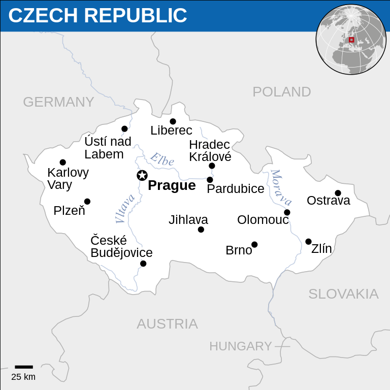
English: Locator map of Czech Republic. |
| កាលបរិច្ឆេទ | |
| ប្រភព |
English: Czech Republic Locator Map (ReliefWeb), ESRI, UNCS, Natural Earth |
| អ្នកនិពន្ធ | |
| SVG genesis | រូបភាពក្រាភិកវ៉ិចទ័រនេះត្រូវបានបង្កើតឡើងដោយប្រើ Inkscape. |
ការដាក់អាជ្ញាប័ណ្ណ
- អ្នកមានសិទ្ធិ៖
- ចែកចាយ – ថតចំលងនិងចែកចាយស្នាដៃនេះ
- កែច្នៃ – កែច្នៃយកទៅប្រើ
- ក្រោមលក្ខខណ្ឌដូចតទៅនេះ៖
- ភាពជាម្ចាស់កម្មសិទ្ធ – You must give appropriate credit, provide a link to the license, and indicate if changes were made. You may do so in any reasonable manner, but not in any way that suggests the licensor endorses you or your use.
 This map is part of a collection of 216 free country maps, created by the UN Office for the Coordination of Humanitarian Affairs (OCHA), to be used in print, web or broadcast products.
The ReliefWeb Location Maps released here are maps that highlight a country, its capital, major populated places and the surrounding regions. Attribution Requirements
Using the map without modifications: ensure that the sources and the disclaimer are below the map. Credit as follows: "Credit: OCHA". For use with alteration: remove the OCHA logo and disclaimer following any modification to the map, but keep the data sources as mentioned below the map. Credit the modified map as follows: "Based on OCHA map". You are responsible for the content of your map. We are keen to receive your feedback and hear how you used OCHA's maps. We would be grateful if you would notify us by e-mail and share your work with us. UN Disclaimer
The designations employed and the presentation of material of this map do not imply the expression of any opinion whatsoever on the part of the Secretariat of the United Nations concerning the legal status of any country, territory, city or area or of its authorities or concerning the delimitation of its frontiers or boundaries. |

|
Textual information (e.g. timestamp) once visible in the image itself has been moved into the image metadata and/or image description page. This makes the image easier to reuse and more language-neutral, and makes the text easier to process and search for. Commons discourages placing visible textual information in images. All licenses accepted on Commons permit this type of modification as a derivative work.
If attribution information were removed and the image is not public domain, replace this tag with {{Attribution metadata from licensed image}}.
|
ប្រវត្តិឯកសារ
ចុចលើម៉ោងនិងកាលបរិច្ឆេទដើម្បីមើលឯកសារដែលបានផ្ទុកឡើងនៅពេលនោះ។
| ម៉ោងនិងកាលបរិច្ឆេទ | កូនរូបភាព | វិមាត្រ | អ្នកប្រើប្រាស់ | យោបល់ | |
|---|---|---|---|---|---|
| បច្ចុប្បន្ន | ម៉ោង១០:១៨ ថ្ងៃព្រហស្បតិ៍ ទី១៨ ខែកុម្ភៈ ឆ្នាំ២០១៦ | | ២៥០ × ២៥០ (៩១៨គីឡូបៃ) | Wereldburger758 | Resized page to drawing. Removal watermark. Validation of image. |
| ម៉ោង០៤:០៣ ថ្ងៃសុក្រ ទី១៨ ខែមេសា ឆ្នាំ២០១៤ |  | ២៥៤ × ២៥៤ (៨៩៩គីឡូបៃ) | UN OCHA maps bot | == {{int:filedesc}} == {{Information |description={{en|1=Locator Map of Czech Republic. {{OCHA map}}}} |date=2013 |source={{en|1=[http://reliefweb.int/map/czech-republic/czech-republic-location-map-2013 Czech Republic Locator Ma... |
បម្រើបម្រាស់ឯកសារ
គ្មានទំព័រណាមួយដែលប្រើប្រាស់ឯកសារនេះទេ។
បម្រើបម្រាស់ឯកសារជាសាកល
វីគីដទៃទៀតដូចខាងក្រោមនេះប្រើប្រាស់ឯកសារនេះ៖
- ការប្រើប្រាស់នៅក្នុង sat.wikipedia.org
_-_CZE_-_UNOCHA.svg)