ឯកសារ:EGY orthographic.svg

Size of this PNG preview of this SVG file: ៥៥០ × ៥៥០ ភីកសែ. ភាពម៉ត់ផ្សេងទៀត៖ ២៤០ × ២៤០ ភីកសែ | ៤៨០ × ៤៨០ ភីកសែ | ៧៦៨ × ៧៦៨ ភីកសែ | ១០២៤ × ១០២៤ ភីកសែ | ២០៤៨ × ២០៤៨ ភីកសែ។
រូបភាពដើម (ឯកសារប្រភេទSVG ៥៥០ × ៥៥០ ភីកសែល ទំហំឯកសារ៖ ១.៣៥មេកាបៃ)
ចំណារពន្យល់
| ការពិពណ៌នា |
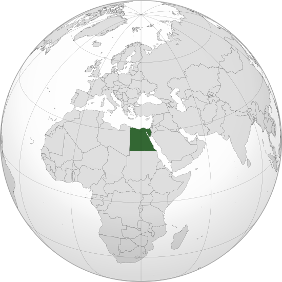
English: Orthographic map of Egypt centered at 26° N, 30º E.
Official territory.
Claimed territories. |
| កាលបរិច្ឆេទ | |
| ប្រភព |
ការងារផ្ទាល់របស់អ្នកផ្ទុកឡើង with Natural Earth Data រូបភាពក្រាភិកវ៉ិចទ័រនេះត្រូវបានបង្កើតឡើងដោយប្រើ Inkscape . |
| អ្នកនិពន្ធ | Addicted04 |
ការដាក់អាជ្ញាប័ណ្ណ
I, the copyright holder of this work, hereby publish it under the following license:
ឯកសារនេះជាប់អាជ្ញាបណ្ឌCreative Commons Attribution-Share Alike 3.0 Unported។
- អ្នកមានសិទ្ធិ៖
- ចែកចាយ – ថតចំលងនិងចែកចាយស្នាដៃនេះ
- កែច្នៃ – កែច្នៃយកទៅប្រើ
- ក្រោមលក្ខខណ្ឌដូចតទៅនេះ៖
- ភាពជាម្ចាស់កម្មសិទ្ធ – You must give appropriate credit, provide a link to the license, and indicate if changes were made. You may do so in any reasonable manner, but not in any way that suggests the licensor endorses you or your use.
- share alike – If you remix, transform, or build upon the material, you must distribute your contributions under the same or compatible license as the original.
ប្រវត្តិឯកសារ
ចុចលើម៉ោងនិងកាលបរិច្ឆេទដើម្បីមើលឯកសារដែលបានផ្ទុកឡើងនៅពេលនោះ។
| ម៉ោងនិងកាលបរិច្ឆេទ | កូនរូបភាព | វិមាត្រ | អ្នកប្រើប្រាស់ | យោបល់ | |
|---|---|---|---|---|---|
| បច្ចុប្បន្ន | ម៉ោង១៩:២៦ ថ្ងៃសុក្រ ទី០៩ ខែកញ្ញា ឆ្នាំ២០២២ | | ៥៥០ × ៥៥០ (១.៣៥មេកាបៃ) | Salma3232 | Reverted to version as of 01:19, 11 January 2022 (UTC) |
| ម៉ោង១៧:១៦ ថ្ងៃពុធ ទី២៧ ខែកក្កដា ឆ្នាំ២០២២ |  | ៥៥០ × ៥៥០ (១.៣៤មេកាបៃ) | عبد العزيز علي | Reverted to version as of 23:54, 11 July 2012 (UTC) | |
| ម៉ោង០១:១៩ ថ្ងៃអង្គារ ទី១១ ខែមករា ឆ្នាំ២០២២ |  | ៥៥០ × ៥៥០ (១.៣៥មេកាបៃ) | Бмхүн | Reverted to version as of 11:02, 7 July 2017 (UTC) | |
| ម៉ោង១៧:៣៧ ថ្ងៃអង្គារ ទី០៩ ខែវិច្ឆិកា ឆ្នាំ២០២១ |  | ៥៥០ × ៥៥០ (១.៣៤មេកាបៃ) | Wa dou13 | Reverted to version as of 23:54, 11 July 2012 (UTC) | |
| ម៉ោង១១:០២ ថ្ងៃសុក្រ ទី០៧ ខែកក្កដា ឆ្នាំ២០១៧ |  | ៥៥០ × ៥៥០ (១.៣៥មេកាបៃ) | Nicolay Sidorov | Kosovo, Somaliland and Northern Cyprus are not full-recognized states | |
| ម៉ោង២៣:៥៤ ថ្ងៃពុធ ទី១១ ខែកក្កដា ឆ្នាំ២០១២ |  | ៥៥០ × ៥៥០ (១.៣៤មេកាបៃ) | Addicted04 |
បម្រើបម្រាស់ឯកសារ
ទំព័រ ខាងក្រោមប្រើប្រាស់ឯកសារនេះ ៖
បម្រើបម្រាស់ឯកសារជាសាកល
វីគីដទៃទៀតដូចខាងក្រោមនេះប្រើប្រាស់ឯកសារនេះ៖
- ការប្រើប្រាស់នៅក្នុង ami.wikipedia.org
- ការប្រើប្រាស់នៅក្នុង ar.wikipedia.org
- مصر
- مستخدم:جار الله/قائمة صور مقالات العلاقات الثنائية
- العلاقات الأنغولية المصرية
- العلاقات الإريترية المصرية
- العلاقات السويسرية المصرية
- العلاقات الليختنشتانية المصرية
- العلاقات البوليفية المصرية
- العلاقات المصرية الموزمبيقية
- العلاقات الألبانية المصرية
- العلاقات البلجيكية المصرية
- العلاقات البيلاروسية المصرية
- العلاقات الطاجيكستانية المصرية
- العلاقات الرومانية المصرية
- العلاقات الغامبية المصرية
- العلاقات السيراليونية المصرية
- العلاقات المصرية النيبالية
- العلاقات الليبيرية المصرية
- العلاقات التشيكية المصرية
- العلاقات المصرية الميانمارية
- العلاقات الكوستاريكية المصرية
- العلاقات الكولومبية المصرية
- العلاقات الكيريباتية المصرية
- العلاقات اللاتفية المصرية
- العلاقات اللاوسية المصرية
- العلاقات اللوكسمبورغية المصرية
- العلاقات الليتوانية المصرية
- العلاقات الليسوتوية المصرية
- العلاقات المالاوية المصرية
- العلاقات المالطية المصرية
- العلاقات المالية المصرية
- العلاقات الماليزية المصرية
- العلاقات المدغشقرية المصرية
- العلاقات المصرية الناوروية
- العلاقات المصرية الهندوراسية
- العلاقات المصرية النيكاراغوية
- العلاقات المصرية المولدوفية
- العلاقات المصرية الناميبية
- العلاقات المصرية الموريشيوسية
- العلاقات المصرية النيوزيلندية
- العلاقات المصرية الهايتية
- العلاقات المصرية الميكرونيسية
- العلاقات المصرية الموريتانية
- العلاقات الزيمبابوية المصرية
- العلاقات البالاوية المصرية
- العلاقات الفانواتية المصرية
- العلاقات الغابونية المصرية
- العلاقات البنمية المصرية
- العلاقات الجورجية المصرية
- العلاقات الأسترالية المصرية
View more global usage of this file.