ឯកសារ:EU-Netherlands.svg

Size of this PNG preview of this SVG file: ៧១៣ × ៦០០ ភីកសែ. ភាពម៉ត់ផ្សេងទៀត៖ ២៨៥ × ២៤០ ភីកសែ | ៥៧១ × ៤៨០ ភីកសែ | ៩១៣ × ៧៦៨ ភីកសែ | ១២១៨ × ១០២៤ ភីកសែ | ២៤៣៥ × ២០៤៨ ភីកសែ | ២០៤៥ × ១៧២០ ភីកសែ។
រូបភាពដើម (ឯកសារប្រភេទSVG ២០៤៥ × ១៧២០ ភីកសែល ទំហំឯកសារ៖ ៧.៤មេកាបៃ)
ចំណារពន្យល់
| ការពិពណ៌នា |
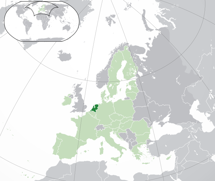
English: (Dark-Green) the Netherlands. (Light-Green) The rest of the European Union (EU). (Dark-gray) The rest of Europe. (Light-gray) The surrounding region.
See also: |
| SVG genesis | ធំរូបភាពក្រាភិកវ៉ិចទ័រនេះត្រូវបានបង្កើតឡើងដោយប្រើ Inkscape. |
| កាលបរិច្ឆេទ | |
| ប្រភព | |
| អ្នកនិពន្ធ | NuclearVacuum |
| ទំរង់ផ្សេងទៀត |
.svg)
ការដាក់អាជ្ញាប័ណ្ណ
I, the copyright holder of this work, hereby publish it under the following licenses:
ឯកសារនេះជាប់អាជ្ញាបណ្ឌCreative Commons Attribution-Share Alike 3.0 Unported។
- អ្នកមានសិទ្ធិ៖
- ចែកចាយ – ថតចំលងនិងចែកចាយស្នាដៃនេះ
- កែច្នៃ – កែច្នៃយកទៅប្រើ
- ក្រោមលក្ខខណ្ឌដូចតទៅនេះ៖
- ភាពជាម្ចាស់កម្មសិទ្ធ – You must give appropriate credit, provide a link to the license, and indicate if changes were made. You may do so in any reasonable manner, but not in any way that suggests the licensor endorses you or your use.
- share alike – If you remix, transform, or build upon the material, you must distribute your contributions under the same or compatible license as the original.

|
រូបភាពនៃទំព័រនេះជាកម្មសិទ្ធិរបស់GNU Free Documentation License។ Version 1.2 ឬក៏ខ្ពស់ជាងនេះត្រូវបានឧបត្ថមគាំទ្រដោយ មូលនិធិសូហ្វវែរដោយឥតគិតថ្លៃ (Free Software Foundation) ដែលមិនមានផ្នែកណាមួយរបស់ប្រភពដើមរួមទាំងអក្សរនៅលើគំរបមុខនិងខ្នង ត្រូវបានផ្លាស់ប្តូរទេ។ ចំពោះផ្នែកដែលមិនអាចផ្លាស់ប្តូរបាន សូមមើលGNU Free Documentation License។ |
You may select the license of your choice.
ប្រវត្តិឯកសារ
ចុចលើម៉ោងនិងកាលបរិច្ឆេទដើម្បីមើលឯកសារដែលបានផ្ទុកឡើងនៅពេលនោះ។
| ម៉ោងនិងកាលបរិច្ឆេទ | កូនរូបភាព | វិមាត្រ | អ្នកប្រើប្រាស់ | យោបល់ | |
|---|---|---|---|---|---|
| បច្ចុប្បន្ន | ម៉ោង០៧:៥៩ ថ្ងៃសៅរ៍ ទី៣០ ខែឧសភា ឆ្នាំ២០២០ | | ២០៤៥ × ១៧២០ (៧.៤មេកាបៃ) | Thayts | Fixed viewport outline on inserted map |
| ម៉ោង០៥:១៥ ថ្ងៃសៅរ៍ ទី០១ ខែកុម្ភៈ ឆ្នាំ២០២០ |  | ២០៤៥ × ១៧២០ (៧.៣៣មេកាបៃ) | Rob984 | UK and Gibraltar have left the EU. New base which includes all of Portugal's islands within frame, as well as Arctic Russian islands part of Europe. Also fixed Flevoland in the Netherlands. | |
| ម៉ោង២០:៣៣ ថ្ងៃអង្គារ ទី២៥ ខែតុលា ឆ្នាំ២០១៦ |  | ២០៤៥ × ១៧២០ (៧.៣២មេកាបៃ) | Giorgi Balakhadze | Rv of sockpuppet and per COM:OVERWRITE | |
| ម៉ោង១៦:២៦ ថ្ងៃពុធ ទី១៨ ខែមីនា ឆ្នាំ២០១៥ |  | ២០៤៥ × ១៧២០ (៧.៣៨មេកាបៃ) | Mapclean | Reverted to Leftcry's version, please go to your talk page | |
| ម៉ោង១៧:២៦ ថ្ងៃច័ន្ទ ទី០៩ ខែកុម្ភៈ ឆ្នាំ២០១៥ |  | ២០៤៥ × ១៧២០ (២.៦១មេកាបៃ) | VS6507 | Please don't change the consensus version | |
| ម៉ោង២១:៤៦ ថ្ងៃអង្គារ ទី០២ ខែធ្នូ ឆ្នាំ២០១៤ |  | ២០៤៥ × ១៧២០ (៧.៣៨មេកាបៃ) | Bobrayner | Back to the more accurate version | |
| ម៉ោង១៥:២៦ ថ្ងៃច័ន្ទ ទី១៧ ខែវិច្ឆិកា ឆ្នាំ២០១៤ |  | ២០៤៥ × ១៧២០ (២.៦១មេកាបៃ) | VS6507 | Reverted to version as of 16:35, 16 November 2014 | |
| ម៉ោង១៩:៣៥ ថ្ងៃអាទិត្យ ទី១៦ ខែវិច្ឆិកា ឆ្នាំ២០១៤ |  | ២០៤៥ × ១៧២០ (៧.៣៨មេកាបៃ) | Leftcry | Reverted to version as of 22:27, 18 October 2014 Please go to your talk page | |
| ម៉ោង១៦:៣៥ ថ្ងៃអាទិត្យ ទី១៦ ខែវិច្ឆិកា ឆ្នាំ២០១៤ |  | ២០៤៥ × ១៧២០ (២.៦១មេកាបៃ) | A2D2 | The map must show the original de-jure status with no breakaway regions, as it was originally created. An alternative map showing the de-facto status with breakaway regions needs to be created instead. | |
| ម៉ោង១៥:៤៦ ថ្ងៃអាទិត្យ ទី១៦ ខែវិច្ឆិកា ឆ្នាំ២០១៤ |  | ២០៤៥ × ១៧២០ (៧.៣៨មេកាបៃ) | A2D2 | Reverted to version as of 21:30, 18 October 2014 |
បម្រើបម្រាស់ឯកសារ
ទំព័រ ខាងក្រោមប្រើប្រាស់ឯកសារនេះ ៖
បម្រើបម្រាស់ឯកសារជាសាកល
វីគីដទៃទៀតដូចខាងក្រោមនេះប្រើប្រាស់ឯកសារនេះ៖
- ការប្រើប្រាស់នៅក្នុង af.wikipedia.org
- ការប្រើប្រាស់នៅក្នុង als.wikipedia.org
- ការប្រើប្រាស់នៅក្នុង ami.wikipedia.org
- ការប្រើប្រាស់នៅក្នុង ang.wikipedia.org
- ការប្រើប្រាស់នៅក្នុង an.wikipedia.org
- ការប្រើប្រាស់នៅក្នុង arc.wikipedia.org
- ការប្រើប្រាស់នៅក្នុង ar.wikipedia.org
- ការប្រើប្រាស់នៅក្នុង arz.wikipedia.org
- ការប្រើប្រាស់នៅក្នុង avk.wikipedia.org
- ការប្រើប្រាស់នៅក្នុង av.wikipedia.org
- ការប្រើប្រាស់នៅក្នុង awa.wikipedia.org
- ការប្រើប្រាស់នៅក្នុង azb.wikipedia.org
- ការប្រើប្រាស់នៅក្នុង az.wikipedia.org
- ការប្រើប្រាស់នៅក្នុង az.wiktionary.org
- ការប្រើប្រាស់នៅក្នុង ban.wikipedia.org
- ការប្រើប្រាស់នៅក្នុង ba.wikipedia.org
- ការប្រើប្រាស់នៅក្នុង be.wikipedia.org
- ការប្រើប្រាស់នៅក្នុង bg.wikipedia.org
- ការប្រើប្រាស់នៅក្នុង bh.wikipedia.org
- ការប្រើប្រាស់នៅក្នុង bi.wikipedia.org
- ការប្រើប្រាស់នៅក្នុង blk.wikipedia.org
- ការប្រើប្រាស់នៅក្នុង bn.wikipedia.org
- ការប្រើប្រាស់នៅក្នុង bo.wikipedia.org
- ការប្រើប្រាស់នៅក្នុង bs.wikipedia.org
- ការប្រើប្រាស់នៅក្នុង bxr.wikipedia.org
- ការប្រើប្រាស់នៅក្នុង ca.wikipedia.org
- ការប្រើប្រាស់នៅក្នុង cdo.wikipedia.org
- ការប្រើប្រាស់នៅក្នុង chr.wikipedia.org
- ការប្រើប្រាស់នៅក្នុង chy.wikipedia.org
- ការប្រើប្រាស់នៅក្នុង ckb.wikipedia.org
- ការប្រើប្រាស់នៅក្នុង co.wikipedia.org
- ការប្រើប្រាស់នៅក្នុង cs.wikipedia.org
- ការប្រើប្រាស់នៅក្នុង cu.wikipedia.org
- ការប្រើប្រាស់នៅក្នុង da.wikipedia.org
- ការប្រើប្រាស់នៅក្នុង da.wiktionary.org
- ការប្រើប្រាស់នៅក្នុង de.wikipedia.org
- ការប្រើប្រាស់នៅក្នុង de.wiktionary.org
View more global usage of this file.