ឯកសារ:EU Member states and Candidate countries map.svg

Size of this PNG preview of this SVG file: ៧០១ × ៥៩៩ ភីកសែ. ភាពម៉ត់ផ្សេងទៀត៖ ២៨១ × ២៤០ ភីកសែ | ៥៦១ × ៤៨០ ភីកសែ | ៨៩៨ × ៧៦៨ ភីកសែ | ១១៩៨ × ១០២៤ ភីកសែ | ២៣៩៥ × ២០៤៨ ភីកសែ | ១៤០១ × ១១៩៨ ភីកសែ។
រូបភាពដើម (ឯកសារប្រភេទSVG ១៤០១ × ១១៩៨ ភីកសែល ទំហំឯកសារ៖ ៨៦០គីឡូបៃ)
ចំណារពន្យល់
| ការពិពណ៌នា |
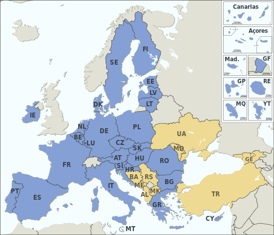
Asturianu: Estaos miembros de la XE (más los países candidatos)
Català: Estats membres de la UE (més els països candidats)
Deutsch: Mitgliedstaaten der EU (+ Bewerberländer)
English: Member states of the EU (plus candidate countries)
Esperanto: Membraj ŝtatoj de EU (kaj kandidataj landoj)
Español: Estados miembros de la UE (más los países candidatos)
Français : Etats membres de l’UE (et pays candidats)
Italiano: Stati membri dell’UE (+ Paesi candidati)
Македонски: Земји членки на ЕУ (+ кандидати)
Member states of the EU Candidate countries
|
|||||||||||||||||||||||||||||||||||||||||||||||||||||||||||||||||||||||||||||||||||
| កាលបរិច្ឆេទ | ||||||||||||||||||||||||||||||||||||||||||||||||||||||||||||||||||||||||||||||||||||
| ប្រភព |
Natural Earth 1:50m (http://www.naturalearthdata.com) This SVG _?_ includes elements from this _?_: |
|||||||||||||||||||||||||||||||||||||||||||||||||||||||||||||||||||||||||||||||||||
| អ្នកនិពន្ធ | Alexrk2 | |||||||||||||||||||||||||||||||||||||||||||||||||||||||||||||||||||||||||||||||||||
| ទំរង់ផ្សេងទៀត |
|
|||||||||||||||||||||||||||||||||||||||||||||||||||||||||||||||||||||||||||||||||||
| SVG genesis | រូបភាពក្រាភិកវ៉ិចទ័រនេះត្រូវបានបង្កើតឡើងដោយប្រើ Batik. and with Inkscape.
រូបភាពក្រាភិករ៉ាស្តានេះត្រូវបានបង្កើតឡើងដោយប្រើ GeoTools.
|


ការដាក់អាជ្ញាប័ណ្ណ
I, the copyright holder of this work, hereby publish it under the following license:
ឯកសារនេះជាប់អាជ្ញាបណ្ឌCreative Commons Attribution-Share Alike 3.0 Unported។
- អ្នកមានសិទ្ធិ៖
- ចែកចាយ – ថតចំលងនិងចែកចាយស្នាដៃនេះ
- កែច្នៃ – កែច្នៃយកទៅប្រើ
- ក្រោមលក្ខខណ្ឌដូចតទៅនេះ៖
- ភាពជាម្ចាស់កម្មសិទ្ធ – You must give appropriate credit, provide a link to the license, and indicate if changes were made. You may do so in any reasonable manner, but not in any way that suggests the licensor endorses you or your use.
- share alike – If you remix, transform, or build upon the material, you must distribute your contributions under the same or compatible license as the original.
ប្រវត្តិឯកសារ
ចុចលើម៉ោងនិងកាលបរិច្ឆេទដើម្បីមើលឯកសារដែលបានផ្ទុកឡើងនៅពេលនោះ។
| ម៉ោងនិងកាលបរិច្ឆេទ | កូនរូបភាព | វិមាត្រ | អ្នកប្រើប្រាស់ | យោបល់ | |
|---|---|---|---|---|---|
| បច្ចុប្បន្ន | ម៉ោង១៧:១១ ថ្ងៃពុធ ទី៣១ ខែមករា ឆ្នាំ២០២៤ | | ១៤០១ × ១១៩៨ (៨៦០គីឡូបៃ) | Janitoalevic | Armenia-Azerbaijan update |
| ម៉ោង០០:២៧ ថ្ងៃសុក្រ ទី១៥ ខែធ្នូ ឆ្នាំ២០២៣ |  | ១៤០១ × ១១៩៨ (៨៦០គីឡូបៃ) | Iktsokh | Georgia is recognized as an official candidate. | |
| ម៉ោង១៦:១២ ថ្ងៃច័ន្ទ ទី០៦ ខែកុម្ភៈ ឆ្នាំ២០២៣ |  | ១៤០១ × ១១៩៨ (៨៦០គីឡូបៃ) | Nestrus | forgot the caption | |
| ម៉ោង១៦:០៧ ថ្ងៃច័ន្ទ ទី០៦ ខែកុម្ភៈ ឆ្នាំ២០២៣ |  | ១៤០១ × ១១៩៨ (៨៥៩គីឡូបៃ) | Nestrus | +candidate Bosnia | |
| ម៉ោង១៨:៥៨ ថ្ងៃព្រហស្បតិ៍ ទី២៣ ខែមិថុនា ឆ្នាំ២០២២ |  | ១៤០១ × ១១៩៨ (៨៤៥គីឡូបៃ) | Cyygma | Ukraine and Modova confirmed as official candidates | |
| ម៉ោង១៥:១៣ ថ្ងៃសៅរ៍ ទី០១ ខែកុម្ភៈ ឆ្នាំ២០២០ |  | ១៤០១ × ១១៩៨ (៨៤៤គីឡូបៃ) | Hansbaer | absurd argument. The map has always followed the development of the EU | |
| ម៉ោង១៤:៤៨ ថ្ងៃសៅរ៍ ទី០១ ខែកុម្ភៈ ឆ្នាំ២០២០ |  | ១៤០១ × ១១៩៨ (៨៤៥គីឡូបៃ) | Alexis Jazz | Reverted to version as of 16:53, 17 March 2015 (UTC) User:Janitoalevic needs to be uploaded as a new file | |
| ម៉ោង២៣:១៥ ថ្ងៃសុក្រ ទី៣១ ខែមករា ឆ្នាំ២០២០ |  | ១៤០១ × ១១៩៨ (៨៤៤គីឡូបៃ) | Janitoalevic | Brexit | |
| ម៉ោង១៦:៥៣ ថ្ងៃអង្គារ ទី១៧ ខែមីនា ឆ្នាំ២០១៥ |  | ១៤០១ × ១១៩៨ (៨៤៥គីឡូបៃ) | Appaches | Ukraine-Crimée : séparation pointillée | |
| ម៉ោង១៧:០៥ ថ្ងៃអាទិត្យ ទី១៥ ខែមីនា ឆ្នាំ២០១៥ |  | ១៤០១ × ១១៩៨ (៨៤៤គីឡូបៃ) | Appaches | Islande retirée |
បម្រើបម្រាស់ឯកសារ
4 ទំព័រ ខាងក្រោមប្រើប្រាស់ឯកសារនេះ ៖
បម្រើបម្រាស់ឯកសារជាសាកល
វីគីដទៃទៀតដូចខាងក្រោមនេះប្រើប្រាស់ឯកសារនេះ៖
- ការប្រើប្រាស់នៅក្នុង ab.wikipedia.org
- ការប្រើប្រាស់នៅក្នុង ar.wikipedia.org
- ការប្រើប្រាស់នៅក្នុង ast.wikipedia.org
- ការប្រើប្រាស់នៅក្នុង az.wikipedia.org
- ការប្រើប្រាស់នៅក្នុង az.wiktionary.org
- ការប្រើប្រាស់នៅក្នុង be-tarask.wikipedia.org
- ការប្រើប្រាស់នៅក្នុង br.wikipedia.org
- ការប្រើប្រាស់នៅក្នុង ca.wikipedia.org
- ការប្រើប្រាស់នៅក្នុង cy.wikipedia.org
- ការប្រើប្រាស់នៅក្នុង da.wikipedia.org
- ការប្រើប្រាស់នៅក្នុង de.wikipedia.org
- Europäische Union
- Portal:Europäische Union
- Mitgliedstaaten der Europäischen Union
- Gebiet der Europäischen Union
- Vorlage:Imagemap Mitgliedstaaten der Europäischen Union
- Vorlage:Imagemap Mitgliedstaaten der Europäischen Union/Test
- Wikipedia:Kartenwerkstatt/Archiv/2011-04
- Benutzer:RickVulcan/Länder Europas
- Extrempunkte der Europäischen Union
- Benutzer:Kpfiwa/Spielwiese/Test
- Benutzer:Oesterreicher12/Spielwiese 2
- Benutzer:HudecEmil
- ការប្រើប្រាស់នៅក្នុង de.wiktionary.org
- ការប្រើប្រាស់នៅក្នុង ext.wikipedia.org
- ការប្រើប្រាស់នៅក្នុង fiu-vro.wikipedia.org
- ការប្រើប្រាស់នៅក្នុង fo.wikipedia.org
- ការប្រើប្រាស់នៅក្នុង frp.wikipedia.org
- ការប្រើប្រាស់នៅក្នុង fr.wikipedia.org
- Élargissement de l'Union européenne
- Droit européen
- Utilisateur:William Pedros
- Modèle:UE-EU-ISO 3166-1 530px
- Union européenne
- Futur élargissement de l'Union européenne
- Wikipédia:Atelier graphique/Cartes/Archives/mai 2014
- Wikipédia:Atelier graphique/Cartes/Archives/mars 2015
- Utilisateur:AlexisN
- Wikipédia:Atelier graphique/Cartes/Archives/août 2017
- ការប្រើប្រាស់នៅក្នុង fr.wikibooks.org
- ការប្រើប្រាស់នៅក្នុង fur.wikipedia.org
- ការប្រើប្រាស់នៅក្នុង fy.wikipedia.org
- ការប្រើប្រាស់នៅក្នុង gd.wikipedia.org
- ការប្រើប្រាស់នៅក្នុង he.wikipedia.org
- ការប្រើប្រាស់នៅក្នុង hr.wikipedia.org
- ការប្រើប្រាស់នៅក្នុង hu.wikipedia.org
- ការប្រើប្រាស់នៅក្នុង hy.wikipedia.org
- ការប្រើប្រាស់នៅក្នុង ia.wikipedia.org
View more global usage of this file.