ឯកសារ:England locator map with North East England highlighted.svg

Size of this PNG preview of this SVG file: ៤៩៤ × ៦០០ ភីកសែ. ភាពម៉ត់ផ្សេងទៀត៖ ១៩៨ × ២៤០ ភីកសែ | ៣៩៥ × ៤៨០ ភីកសែ | ៦៣២ × ៧៦៨ ភីកសែ | ៨៤៣ × ១០២៤ ភីកសែ | ១៦៨៦ × ២០៤៨ ភីកសែ | ៨១៦ × ៩៩១ ភីកសែ។
រូបភាពដើម (ឯកសារប្រភេទSVG ៨១៦ × ៩៩១ ភីកសែល ទំហំឯកសារ៖ ៤៦៩គីឡូបៃ)
| ការពិពណ៌នា |
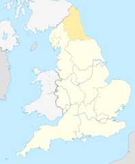
English: Equirectangular projection of England; North East England is highlighted. |
| កាលបរិច្ឆេទ | |
| ប្រភព | File:England location map.svg |
| អ្នកនិពន្ធ | |
| ការអនុញ្ញាត (ប្រើឯកសារនេះឡើងវិញ) |
ឯកសារនេះជាប់អាជ្ញាបណ្ឌCreative Commons Attribution-Share Alike 3.0 Unported។
|
ប្រវត្តិឯកសារ
ចុចលើម៉ោងនិងកាលបរិច្ឆេទដើម្បីមើលឯកសារដែលបានផ្ទុកឡើងនៅពេលនោះ។
| ម៉ោងនិងកាលបរិច្ឆេទ | កូនរូបភាព | វិមាត្រ | អ្នកប្រើប្រាស់ | យោបល់ | |
|---|---|---|---|---|---|
| បច្ចុប្បន្ន | ម៉ោង០៩:៣៤ ថ្ងៃព្រហស្បតិ៍ ទី០៨ ខែមេសា ឆ្នាំ២០១០ | | ៨១៦ × ៩៩១ (៤៦៩គីឡូបៃ) | Jappalang | {{Information |Description=Equirectangular projection of England; Northumberland is highlighted |Source=File:England location map.svg |Date=2010-04-08 |Author=* File:England location map.svg: Spischot * author: [[User:Jappalang |
បម្រើបម្រាស់ឯកសារ
4 ទំព័រ ខាងក្រោមប្រើប្រាស់ឯកសារនេះ ៖
បម្រើបម្រាស់ឯកសារជាសាកល
វីគីដទៃទៀតដូចខាងក្រោមនេះប្រើប្រាស់ឯកសារនេះ៖
- ការប្រើប្រាស់នៅក្នុង am.wikipedia.org
- ការប្រើប្រាស់នៅក្នុង ar.wikipedia.org
- ការប្រើប្រាស់នៅក្នុង as.wikipedia.org
- ការប្រើប្រាស់នៅក្នុង bh.wikipedia.org
- ការប្រើប្រាស់នៅក្នុង blk.wikipedia.org
- ការប្រើប្រាស់នៅក្នុង bn.wikipedia.org
- ការប្រើប្រាស់នៅក្នុង bs.wikipedia.org
- ការប្រើប្រាស់នៅក្នុង ca.wikipedia.org
- ការប្រើប្រាស់នៅក្នុង cy.wikipedia.org
- ការប្រើប្រាស់នៅក្នុង da.wikipedia.org
- ការប្រើប្រាស់នៅក្នុង diq.wikipedia.org
- ការប្រើប្រាស់នៅក្នុង dty.wikipedia.org
- ការប្រើប្រាស់នៅក្នុង dv.wikipedia.org
- ការប្រើប្រាស់នៅក្នុង en.wikipedia.org
- Template:Location map+
- Template:Location map~
- Template:Location map+/doc
- Template:Location map+/sandbox
- Template:Location map+/testcases
- Template:Location map~/sandbox
- Template:Location map+/AlternativeMap
- User:Arjunaraoc/sandbox/SampleMap1
- User:Arjunaraoc/sandbox/SampleMap2
- User:Arjunaraoc/sandbox/SampleMap3
- ការប្រើប្រាស់នៅក្នុង en.wikibooks.org
- ការប្រើប្រាស់នៅក្នុង en.wikiversity.org
- ការប្រើប្រាស់នៅក្នុង fa.wikipedia.org
View more global usage of this file.