ឯកសារ:Europe ISO 3166-1.svg

Size of this PNG preview of this SVG file: ៧០០ × ៥១២ ភីកសែ. ភាពម៉ត់ផ្សេងទៀត៖ ៣២០ × ២៣៤ ភីកសែ | ៦៤០ × ៤៦៨ ភីកសែ | ១០២៤ × ៧៤៩ ភីកសែ | ១២៨០ × ៩៣៦ ភីកសែ | ២៥៦០ × ១៨៧២ ភីកសែ។
រូបភាពដើម (ឯកសារប្រភេទSVG ៧០០ × ៥១២ ភីកសែល ទំហំឯកសារ៖ ៣៨៤គីឡូបៃ)
ចំណារពន្យល់
| ការពិពណ៌នា |
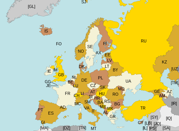
Map of Europe, with ISO 3166-1 pt · en country and territory codes. SVG format. Map legend in Portuguese and English, with name of sovereign state given in parenthesis, where applicable:
Non-European countries and territories featured in map:
|
| កាលបរិច្ឆេទ | |
| ប្រភព | ការងារផ្ទាល់របស់អ្នកផ្ទុកឡើង |
| អ្នកនិពន្ធ | Júlio Reis |
| ទំរង់ផ្សេងទៀត | Without country codes: Europe countries.svg · Only continent boundaries: Europe continents.svg · Country names in Italian: Europa-it-politica-names-big.svg · Including Kosovo: Europe ISO 3166-1 (with Kosovo).svg |
| SVG genesis | រូបភាពក្រាភិកវ៉ិចទ័រនេះត្រូវបានបង្កើតឡើងដោយប្រើ Inkscape. This map uses embedded text. |
.svg)
ការដាក់អាជ្ញាប័ណ្ណ
ឯកសារនេះជាប់អាជ្ញាបណ្ឌCreative Commons Attribution-Share Alike 3.0 Unported។
- អ្នកមានសិទ្ធិ៖
- ចែកចាយ – ថតចំលងនិងចែកចាយស្នាដៃនេះ
- កែច្នៃ – កែច្នៃយកទៅប្រើ
- ក្រោមលក្ខខណ្ឌដូចតទៅនេះ៖
- ភាពជាម្ចាស់កម្មសិទ្ធ – You must give appropriate credit, provide a link to the license, and indicate if changes were made. You may do so in any reasonable manner, but not in any way that suggests the licensor endorses you or your use.
- share alike – If you remix, transform, or build upon the material, you must distribute your contributions under the same or compatible license as the original.
ប្រវត្តិឯកសារ
ចុចលើម៉ោងនិងកាលបរិច្ឆេទដើម្បីមើលឯកសារដែលបានផ្ទុកឡើងនៅពេលនោះ។
| ម៉ោងនិងកាលបរិច្ឆេទ | កូនរូបភាព | វិមាត្រ | អ្នកប្រើប្រាស់ | យោបល់ | |
|---|---|---|---|---|---|
| បច្ចុប្បន្ន | ម៉ោង២២:៤៣ ថ្ងៃច័ន្ទ ទី១០ ខែសីហា ឆ្នាំ២០១៥ | | ៧០០ × ៥១២ (៣៨៤គីឡូបៃ) | SiBr4 | Increasing contrast by slightly changing the map colors; splitting Serbia and Montenegro; cropping some more; plain SVG |
| ម៉ោង១៨:៤៦ ថ្ងៃអង្គារ ទី១០ ខែមេសា ឆ្នាំ២០១២ |  | ៨០០ × ៥១២ (៤២១គីឡូបៃ) | Ras67 | "cropped" | |
| ម៉ោង០៤:៥២ ថ្ងៃអាទិត្យ ទី១៣ ខែមីនា ឆ្នាំ២០១១ |  | ៨០០ × ៥២០ (៥៩៧គីឡូបៃ) | Chipmunkdavis | Fixing Turkey, adding Gibraltar | |
| ម៉ោង២៣:១១ ថ្ងៃសៅរ៍ ទី២២ ខែសីហា ឆ្នាំ២០០៩ |  | ៨០០ × ៥២០ (៥៩៩គីឡូបៃ) | Tintazul | Croatia, Palestine | |
| ម៉ោង២៣:១៥ ថ្ងៃអាទិត្យ ទី០៤ ខែវិច្ឆិកា ឆ្នាំ២០០៧ |  | ៨០០ × ៥២០ (៦០១គីឡូបៃ) | Lupo | Re-upload; trying to fix wrong MIME type | |
| ម៉ោង១៣:០៦ ថ្ងៃអង្គារ ទី១៤ ខែសីហា ឆ្នាំ២០០៧ | គ្មានកូនរូបភាព | (៦០១គីឡូបៃ) | Tintazul | replaced CS with RS+ME; replaced UK with GB; added AX, SJ, FO, IM, GG, JE | |
| ម៉ោង០១:៣២ ថ្ងៃព្រហស្បតិ៍ ទី១១ ខែមករា ឆ្នាំ២០០៧ |  | ៨០០ × ៥២០ (៥៩៤គីឡូបៃ) | Angus | PT → HR | |
| ម៉ោង២១:៥១ ថ្ងៃពុធ ទី០៧ ខែមិថុនា ឆ្នាំ២០០៦ |  | ៨០០ × ៥២០ (៥៩៤គីឡូបៃ) | Tintazul | {{Tintazul| |Description=Map of Europe, with ISO 3166-1 <sup>pt · en</sup> country and territory codes. SVG format. Map legend in Portuguese and English, with name of sovereign state given in parenthesis, where appl |
បម្រើបម្រាស់ឯកសារ
គ្មានទំព័រណាមួយដែលប្រើប្រាស់ឯកសារនេះទេ។
បម្រើបម្រាស់ឯកសារជាសាកល
វីគីដទៃទៀតដូចខាងក្រោមនេះប្រើប្រាស់ឯកសារនេះ៖
- ការប្រើប្រាស់នៅក្នុង ar.wikipedia.org
- ការប្រើប្រាស់នៅក្នុង arz.wikipedia.org
- ការប្រើប្រាស់នៅក្នុង bg.wikipedia.org
- ការប្រើប្រាស់នៅក្នុង bn.wikipedia.org
- ការប្រើប្រាស់នៅក្នុង cs.wikipedia.org
- ការប្រើប្រាស់នៅក្នុង en.wikipedia.org
- ការប្រើប្រាស់នៅក្នុង eo.wikipedia.org
- ការប្រើប្រាស់នៅក្នុង es.wikipedia.org
- ការប្រើប្រាស់នៅក្នុង fi.wikipedia.org
- ការប្រើប្រាស់នៅក្នុង fo.wikipedia.org
- ការប្រើប្រាស់នៅក្នុង fr.wikipedia.org
- ការប្រើប្រាស់នៅក្នុង gl.wikipedia.org
- ការប្រើប្រាស់នៅក្នុង he.wikipedia.org
- ការប្រើប្រាស់នៅក្នុង id.wikipedia.org
- ការប្រើប្រាស់នៅក្នុង ilo.wikipedia.org
- ការប្រើប្រាស់នៅក្នុង ja.wikipedia.org
- ការប្រើប្រាស់នៅក្នុង ka.wikipedia.org
- ការប្រើប្រាស់នៅក្នុង lt.wikipedia.org
- ការប្រើប្រាស់នៅក្នុង mk.wikipedia.org
- ការប្រើប្រាស់នៅក្នុង nl.wikipedia.org
- ការប្រើប្រាស់នៅក្នុង no.wikipedia.org
- ការប្រើប្រាស់នៅក្នុង pt.wikipedia.org
- ការប្រើប្រាស់នៅក្នុង ru.wikipedia.org
- ការប្រើប្រាស់នៅក្នុង rw.wikipedia.org
- ការប្រើប្រាស់នៅក្នុង si.wikipedia.org
- ការប្រើប្រាស់នៅក្នុង sr.wikipedia.org
- ការប្រើប្រាស់នៅក្នុង su.wikipedia.org
- ការប្រើប្រាស់នៅក្នុង ta.wikipedia.org
- ការប្រើប្រាស់នៅក្នុង www.wikidata.org
- ការប្រើប្រាស់នៅក្នុង zh.wikipedia.org