ឯកសារ:Isaanmountains.png
ទំហំរបស់ការមើលមុននេះ: ៦៦៧ × ៦០០ ភីកសែ។ ភាពម៉ត់ផ្សេងទៀត៖ ២៦៧ × ២៤០ ភីកសែ | ៥៣៤ × ៤៨០ ភីកសែ | ៨៥៤ × ៧៦៨ ភីកសែ | ១១៣៩ × ១០២៤ ភីកសែ | ២២១០ × ១៩៨៧ ភីកសែ។
រូបភាពដើម (២២១០ × ១៩៨៧ ភីកសែល ទំហំឯកសារ៖ ១.០៥មេកាបៃ ប្រភេទ MIME៖ image/png)
| ការពិពណ៌នា |
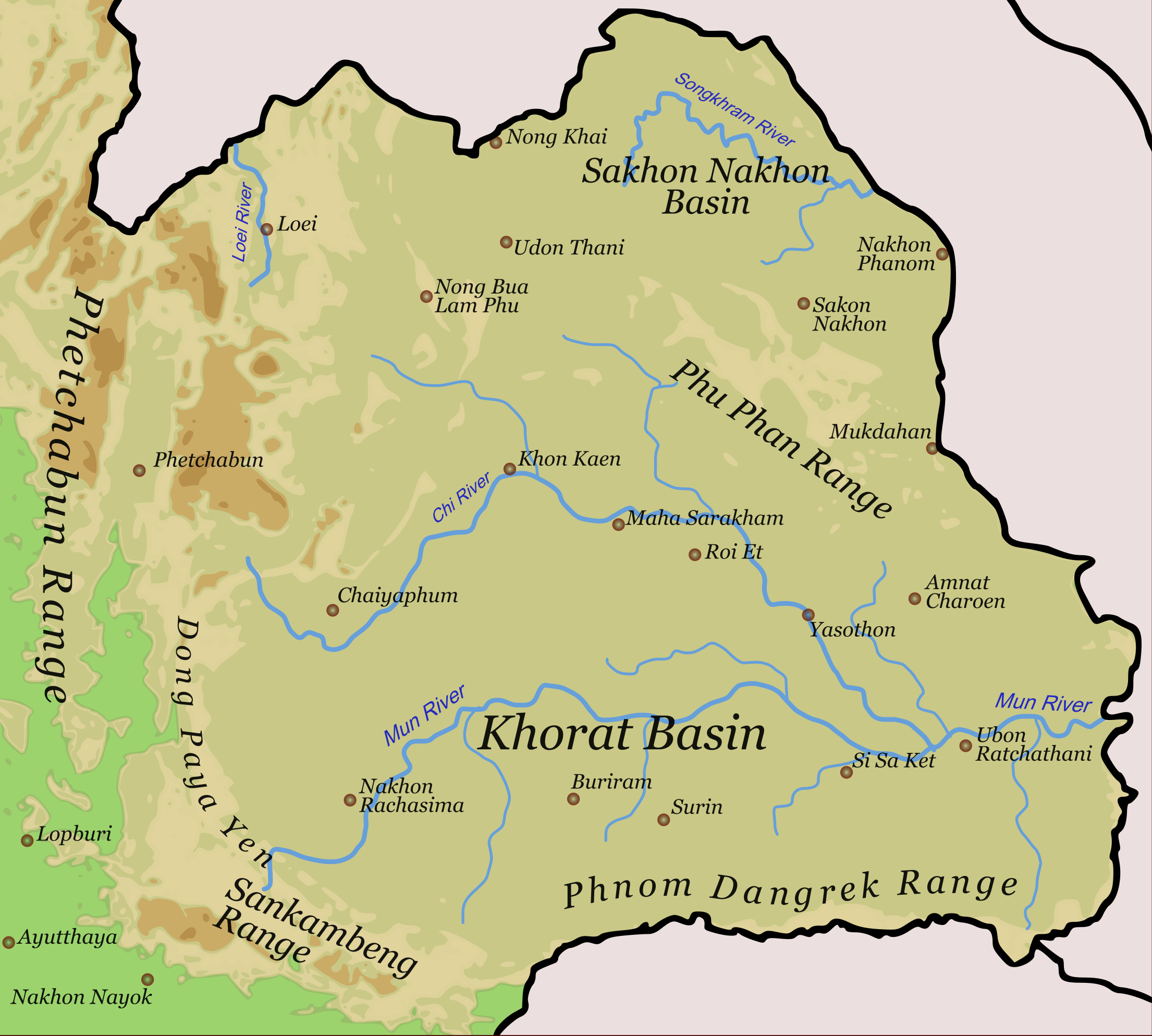
English: Physical orientation map of North-East-Thailand |
||
| កាលបរិច្ឆេទ | |||
| ប្រភព | ការងារផ្ទាល់របស់អ្នកផ្ទុកឡើង | ||
| អ្នកនិពន្ធ | Hdamm | ||
| ការអនុញ្ញាត (ប្រើឯកសារនេះឡើងវិញ) |
I, the copyright holder of this work, hereby publish it under the following licenses:
This file is licensed under the Creative Commons Attribution-Share Alike 4.0 International, 3.0 Unported, 2.5 Generic, 2.0 Generic and 1.0 Generic license.
You may select the license of your choice. |
||
| ទំរង់ផ្សេងទៀត | Isaanmountains.svg |

ប្រវត្តិឯកសារ
ចុចលើម៉ោងនិងកាលបរិច្ឆេទដើម្បីមើលឯកសារដែលបានផ្ទុកឡើងនៅពេលនោះ។
| ម៉ោងនិងកាលបរិច្ឆេទ | កូនរូបភាព | វិមាត្រ | អ្នកប្រើប្រាស់ | យោបល់ | |
|---|---|---|---|---|---|
| បច្ចុប្បន្ន | ម៉ោង១២:១៤ ថ្ងៃសុក្រ ទី០៦ ខែមករា ឆ្នាំ២០១៧ | | ២២១០ × ១៩៨៧ (១.០៥មេកាបៃ) | Paul 012 | Shrink Dong Phaya Yen label, since it encroached into the Eastern Phetchabun Range area |
| ម៉ោង០៣:២៧ ថ្ងៃច័ន្ទ ទី១០ ខែកុម្ភៈ ឆ្នាំ២០១៤ |  | ២២០៩ × ១៩៨៤ (៧១៦គីឡូបៃ) | Ras67 | cropped and optimized | |
| ម៉ោង១៥:០៣ ថ្ងៃសុក្រ ទី២២ ខែសីហា ឆ្នាំ២០០៨ |  | ២២៣៩ × ២០១៤ (១.០១មេកាបៃ) | Hdamm | {{Information |Description= |Source= |Date= |Author= |Permission= |other_versions= }} | |
| ម៉ោង០៨:៥២ ថ្ងៃសុក្រ ទី១៣ ខែមិថុនា ឆ្នាំ២០០៨ |  | ២២៣៩ × ២០១៤ (៨៨៦គីឡូបៃ) | Hdamm | {{Information |Description= |Source= |Date= |Author= |Permission= |other_versions= }} | |
| ម៉ោង១៦:១៤ ថ្ងៃសៅរ៍ ទី៣១ ខែឧសភា ឆ្នាំ២០០៨ |  | ២២៣៩ × ២០១៤ (៨៦៥គីឡូបៃ) | Hdamm | {{Information |Description={{en|1=Physical orientation map of North-East-Thailand}} |Source=Own work by uploader |Author=Hdamm |Date=31.05.2008 |Permission={{self|GFDL|cc-by-sa-all}} |other_versions=Isaanmountains.svg }} {{ImageUpload|full |
បម្រើបម្រាស់ឯកសារ
ទំព័រ ខាងក្រោមប្រើប្រាស់ឯកសារនេះ ៖
បម្រើបម្រាស់ឯកសារជាសាកល
វីគីដទៃទៀតដូចខាងក្រោមនេះប្រើប្រាស់ឯកសារនេះ៖
- ការប្រើប្រាស់នៅក្នុង arz.wikipedia.org
- ការប្រើប្រាស់នៅក្នុង bg.wikipedia.org
- ការប្រើប្រាស់នៅក្នុង ca.wikipedia.org
- ការប្រើប្រាស់នៅក្នុង ceb.wikipedia.org
- ការប្រើប្រាស់នៅក្នុង cs.wikipedia.org
- ការប្រើប្រាស់នៅក្នុង de.wikipedia.org
- ការប្រើប្រាស់នៅក្នុង en.wikipedia.org
- ការប្រើប្រាស់នៅក្នុង en.wikivoyage.org
- ការប្រើប្រាស់នៅក្នុង es.wikipedia.org
- ការប្រើប្រាស់នៅក្នុង fi.wikipedia.org
- ការប្រើប្រាស់នៅក្នុង fr.wikipedia.org
- ការប្រើប្រាស់នៅក្នុង gl.wikipedia.org
- ការប្រើប្រាស់នៅក្នុង he.wikipedia.org
- ការប្រើប្រាស់នៅក្នុង hu.wikipedia.org
- ការប្រើប្រាស់នៅក្នុង it.wikipedia.org
- ការប្រើប្រាស់នៅក្នុង ja.wikipedia.org
- ការប្រើប្រាស់នៅក្នុង ka.wikipedia.org
- ការប្រើប្រាស់នៅក្នុង lld.wikipedia.org
- ការប្រើប្រាស់នៅក្នុង mai.wikipedia.org
- ការប្រើប្រាស់នៅក្នុង ml.wikipedia.org
- ការប្រើប្រាស់នៅក្នុង nl.wikipedia.org
- ការប្រើប្រាស់នៅក្នុង ru.wikipedia.org
- ការប្រើប្រាស់នៅក្នុង sv.wikipedia.org
- ការប្រើប្រាស់នៅក្នុង th.wikipedia.org
- ការប្រើប្រាស់នៅក្នុង uk.wikipedia.org
- ការប្រើប្រាស់នៅក្នុង www.wikidata.org
View more global usage of this file.