ឯកសារ:Japanese Empire2.png
ទំហំរបស់ការមើលមុននេះ: ៥១៥ × ៥៩៩ ភីកសែ។ ភាពម៉ត់ផ្សេងទៀត៖ ២០៦ × ២៤០ ភីកសែ | ៤១២ × ៤៨០ ភីកសែ | ៦៦០ × ៧៦៨ ភីកសែ | ១០៣២ × ១២០១ ភីកសែ។
រូបភាពដើម (១០៣២ × ១២០១ ភីកសែល ទំហំឯកសារ៖ ៩២៧គីឡូបៃ ប្រភេទ MIME៖ image/png)

|
រូបភាព military mapនេះ គួរតែបង្កើតឡើងវិញដោយប្រើក្រាភិកវ៉ិចទ័រ ដែលជាប្រភេទហ្វាល់ SVG ។ ការបង្កើតរូបភាពជាហ្វាល់ SVG ផ្តល់នូវអត្ថប្រយោជន៍ជាច្រើន។ ចំពោះព័ត៌មានបន្ថែម សូមមើល Commons:Media for cleanup ។ ប្រសិនបើទំរង់ SVG នៃរូបភាពនេះត្រូវបានបង្កើតរួចរាល់ហើយ សូមអាប់ឡូដវា។ បន្ទាប់ពីអាប់ឡូដជាទំរង់ SVG សូមជំនួសទំព័រគំរូនេះដោយ {{vector version available|ឈ្មោះរូបភាពថ្មី.svg}} ។
|
ចំណារពន្យល់
| ការពិពណ៌នា |
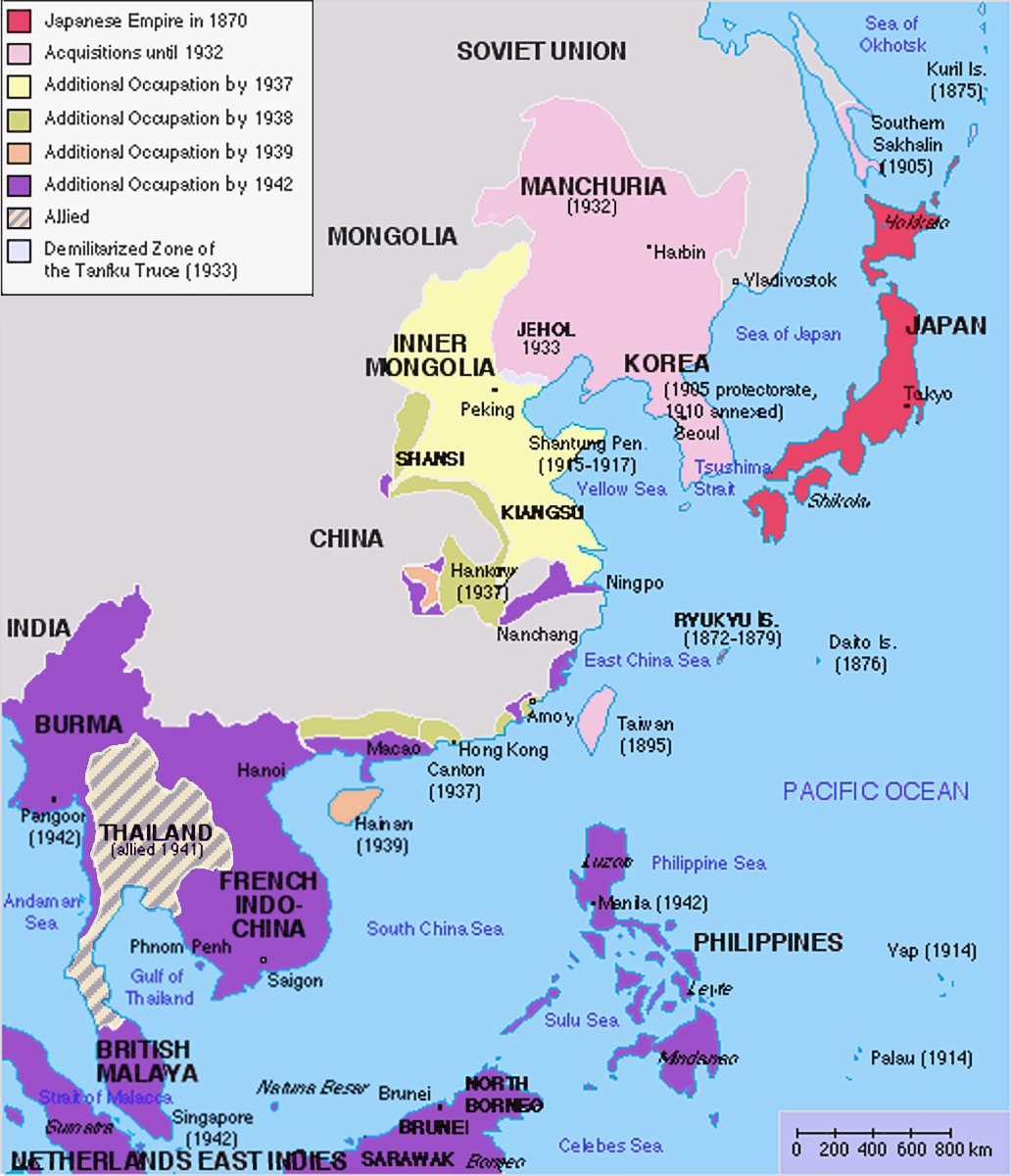
English: Original map was created by Kokiri, based in part on File:BlankMap-World.png. Subsequent modifications to colors performed by Huhsunqu. Additional corrections (fixed Ryukyu Islands, Sichuan, grammar in table) by Markalexander100. |
||||||||
| កាលបរិច្ឆេទ | (original upload date at English Wikipedia) | ||||||||
| ប្រភព |
This file was derived from: Japanese Empire.png |
||||||||
| អ្នកនិពន្ធ | Kokiri at អង់គ្លេស វិគីភីឌា, modifications by Huhsunqu and Markalexander100. | ||||||||
| ការអនុញ្ញាត (ប្រើឯកសារនេះឡើងវិញ) |
|
||||||||
| ទំរង់ផ្សេងទៀត |
Derivative works of this file: |

.png)
Original upload log
The original upload log was here. The usernames refer to the English Wikipedia. Not to be confused with File:Japanese empire.png.
04:00, 6 October 2005 . . Huhsunqu (talk | contribs | block) 508 × 591 (44,305 bytes)02:42, 21 August 2004 . . Nanshu (talk | contribs | block) 508 × 591 (45,178 bytes)09:38, 18 August 2004 . . Kokiri (talk | contribs | block) 508 × 591 (46,867 bytes) (map of the Japanese Empire, drawn myself)
ប្រវត្តិឯកសារ
ចុចលើម៉ោងនិងកាលបរិច្ឆេទដើម្បីមើលឯកសារដែលបានផ្ទុកឡើងនៅពេលនោះ។
| ម៉ោងនិងកាលបរិច្ឆេទ | កូនរូបភាព | វិមាត្រ | អ្នកប្រើប្រាស់ | យោបល់ | |
|---|---|---|---|---|---|
| បច្ចុប្បន្ន | ម៉ោង១២:២៦ ថ្ងៃសុក្រ ទី០៣ ខែមីនា ឆ្នាំ២០២៣ | | ១០៣២ × ១២០១ (៩២៧គីឡូបៃ) | Hohum | Brighten |
| ម៉ោង១២:២៤ ថ្ងៃសុក្រ ទី០៣ ខែមីនា ឆ្នាំ២០២៣ |  | ១០៣២ × ១២០១ (៩៤៤គីឡូបៃ) | Hohum | less garish colours | |
| ម៉ោង០៣:៥៣ ថ្ងៃអង្គារ ទី១០ ខែមករា ឆ្នាំ២០២៣ |  | ១០៣២ × ១២០១ (១០២០គីឡូបៃ) | Artanisen | Added allied color. Thailand was in a coerced alliance (1941) thus part of the empire | |
| ម៉ោង០៦:២០ ថ្ងៃពុធ ទី២២ ខែមិថុនា ឆ្នាំ២០២២ |  | ១០៣២ × ១២០១ (៦៨៣គីឡូបៃ) | Crab2814 | Removed Tongking- France gave Japan military access to that region in 1940, not an occupational right. Fixed Sakhalin and Hainan. Removed Thailand, which was allied not occupied by Japan. | |
| ម៉ោង១១:៥៨ ថ្ងៃច័ន្ទ ទី០៣ ខែសីហា ឆ្នាំ២០២០ |  | ១៤៣៧ × ១២០១ (១.៨មេកាបៃ) | Artanisen | Bigger size and sharper version of the same map. The rest is the same. | |
| ម៉ោង១១:៤៧ ថ្ងៃព្រហស្បតិ៍ ទី០៥ ខែកក្កដា ឆ្នាំ២០០៧ |  | ៧០៧ × ៥៩១ (៣២គីឡូបៃ) | Mahahahaneapneap | pngcrushed | |
| ម៉ោង០១:៣១ ថ្ងៃអាទិត្យ ទី២៧ ខែឧសភា ឆ្នាំ២០០៧ |  | ៧០៧ × ៥៩១ (៤៨គីឡូបៃ) | Gryffindor | {{svg}} {{GFDL}} Modified version of Image:Japanese_Empire.png. Fixed Ryukyu Islands, Sichuan, grammar in table. Category:Maps of the history of Japan Category:Maps of the history of Korea Category:Maps of the history of Vietnam [[Categ | |
| ម៉ោង១៥:១៣ ថ្ងៃអង្គារ ទី២៧ ខែកុម្ភៈ ឆ្នាំ២០០៧ |  | ៥០៨ × ៥៩១ (៣៦គីឡូបៃ) | Cristan | Optimized using PNGOUT | |
| ម៉ោង១១:២៤ ថ្ងៃព្រហស្បតិ៍ ទី២២ ខែធ្នូ ឆ្នាំ២០០៥ |  | ៥០៨ × ៥៩១ (៤៧គីឡូបៃ) | Markalexander100 | {{GFDL}} Modified version of Image:Japanese_Empire.png. Fixed Ryukyu Islands, Sichuan, grammar in table. |
បម្រើបម្រាស់ឯកសារ
គ្មានទំព័រណាមួយដែលប្រើប្រាស់ឯកសារនេះទេ។
បម្រើបម្រាស់ឯកសារជាសាកល
វីគីដទៃទៀតដូចខាងក្រោមនេះប្រើប្រាស់ឯកសារនេះ៖
- ការប្រើប្រាស់នៅក្នុង af.wikipedia.org
- ការប្រើប្រាស់នៅក្នុង ar.wikipedia.org
- ការប្រើប្រាស់នៅក្នុង bn.wikipedia.org
- ការប្រើប្រាស់នៅក្នុង ca.wikipedia.org
- ការប្រើប្រាស់នៅក្នុង cs.wikipedia.org
- ការប្រើប្រាស់នៅក្នុង de.wikipedia.org
- ការប្រើប្រាស់នៅក្នុង en.wikipedia.org
- ការប្រើប្រាស់នៅក្នុង eu.wikipedia.org
- ការប្រើប្រាស់នៅក្នុង fa.wikipedia.org
- ការប្រើប្រាស់នៅក្នុង fi.wikipedia.org
- ការប្រើប្រាស់នៅក្នុង fr.wikipedia.org
- ការប្រើប្រាស់នៅក្នុង gl.wikipedia.org
- ការប្រើប្រាស់នៅក្នុង hak.wikipedia.org
- ការប្រើប្រាស់នៅក្នុង he.wikipedia.org
- ការប្រើប្រាស់នៅក្នុង hy.wikipedia.org
- ការប្រើប្រាស់នៅក្នុង it.wikipedia.org
- ការប្រើប្រាស់នៅក្នុង ja.wikipedia.org
- ការប្រើប្រាស់នៅក្នុង min.wikipedia.org
- ការប្រើប្រាស់នៅក្នុង mk.wikipedia.org
- ការប្រើប្រាស់នៅក្នុង ms.wikipedia.org
- ការប្រើប្រាស់នៅក្នុង nl.wikipedia.org
- ការប្រើប្រាស់នៅក្នុង oc.wikipedia.org
- ការប្រើប្រាស់នៅក្នុង pam.wikipedia.org
- ការប្រើប្រាស់នៅក្នុង pt.wikipedia.org
- ការប្រើប្រាស់នៅក្នុង ro.wikipedia.org
View more global usage of this file.