ឯកសារ:Japanese Empire - 1942.svg

Size of this PNG preview of this SVG file: ៧៨៨ × ៦០០ ភីកសែ. ភាពម៉ត់ផ្សេងទៀត៖ ៣១៦ × ២៤០ ភីកសែ | ៦៣១ × ៤៨០ ភីកសែ | ១០០៩ × ៧៦៨ ភីកសែ | ១២៨០ × ៩៧៤ ភីកសែ | ២៥៦០ × ១៩៤៨ ភីកសែ | ១១០០ × ៨៣៧ ភីកសែ។
រូបភាពដើម (ឯកសារប្រភេទSVG ១១០០ × ៨៣៧ ភីកសែល ទំហំឯកសារ៖ ៨៧៥គីឡូបៃ)
ចំណារពន្យល់
| ការពិពណ៌នា |
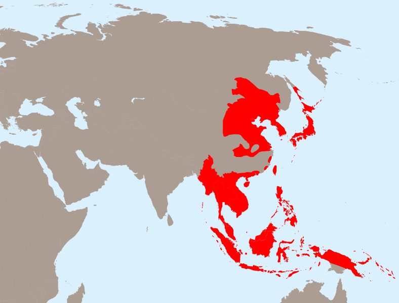
English: The Empire of Japan at its height in 1942.
Français : Japon 1942
Deutsch: Japanisches Reich 1942 |
| កាលបរិច្ឆេទ | |
| ប្រភព | Own work based on: Empire of Japan (1868-1945).png by Mackay 86, Asie.svg by historicair and Japanese Empire2.png by Mackay 86 |
| អ្នកនិពន្ធ |
Vector: |
| SVG genesis | រូបភាពក្រាភិកវ៉ិចទ័រនេះត្រូវបានបង្កើតឡើងដោយប្រើ Inkscape. |
.png)
ការដាក់អាជ្ញាប័ណ្ណ
ឯកសារនេះជាប់អាជ្ញាបណ្ឌCreative Commons Attribution-Share Alike 3.0 Unported។
- អ្នកមានសិទ្ធិ៖
- ចែកចាយ – ថតចំលងនិងចែកចាយស្នាដៃនេះ
- កែច្នៃ – កែច្នៃយកទៅប្រើ
- ក្រោមលក្ខខណ្ឌដូចតទៅនេះ៖
- ភាពជាម្ចាស់កម្មសិទ្ធ – You must give appropriate credit, provide a link to the license, and indicate if changes were made. You may do so in any reasonable manner, but not in any way that suggests the licensor endorses you or your use.
- share alike – If you remix, transform, or build upon the material, you must distribute your contributions under the same or compatible license as the original.
Original upload log
This image is a derivative work of the following images:
- Empire of Japan (1868-1945).png licensed with PD-user-w
- 2010-04-13T05:49:21Z File Upload Bot (Magnus Manske) 1000x600 (183888 Bytes) {{BotMoveToCommons|en.wikipedia|year={{subst:CURRENTYEAR}}|month={{subst:CURRENTMONTHNAME}}|day={{subst:CURRENTDAY}}}} {{Information |Description={{en|The Empire of Japan at its height in 1942.}} |Source=Transferred from [ht
- Asie.svg licensed with PD-self
- 2006-11-23T21:09:53Z Historicair 1100x837 (902355 Bytes)
- 2006-11-23T20:25:19Z Historicair 1100x837 (902408 Bytes)
- 2006-11-22T22:59:34Z Historicair 1100x837 (898316 Bytes)
- 2006-11-21T18:36:45Z Historicair 1100x837 (897827 Bytes)
- 2006-11-20T20:31:48Z Historicair 1100x837 (816138 Bytes) {{Information |Description={{fr|1=Carte vierge de l'Asie }}{{en|1=Asia Blank map}} |Source=http://en.wikipedia.org/wiki/Image:BlankMap-World5.svg |Date=20/11/2006 |Author=~~~~ |Permission={{PD-self}} |other_versions= }} {{Atelier g
- Japanese Empire2.png licensed with Cc-by-sa-3.0-migrated, GFDL
- 2007-07-05T11:47:48Z Mahahahaneapneap 707x591 (32385 Bytes) pngcrushed
- 2007-05-27T01:31:13Z Gryffindor 707x591 (49084 Bytes) {{svg}} {{GFDL}} Modified version of [[:Image:Japanese_Empire.png]]. Fixed Ryukyu Islands, Sichuan, grammar in table. [[Category:Maps of the history of Japan]] [[Category:Maps of the history of Korea]] [[Category:Maps of th
- 2007-02-27T15:13:21Z Cristan 508x591 (37210 Bytes) Optimized using PNGOUT
- 2005-12-22T11:24:51Z Markalexander100 508x591 (47890 Bytes) {{GFDL}} Modified version of [[:Image:Japanese_Empire.png]]. Fixed Ryukyu Islands, Sichuan, grammar in table.
Uploaded with derivativeFX
ប្រវត្តិឯកសារ
ចុចលើម៉ោងនិងកាលបរិច្ឆេទដើម្បីមើលឯកសារដែលបានផ្ទុកឡើងនៅពេលនោះ។
| ម៉ោងនិងកាលបរិច្ឆេទ | កូនរូបភាព | វិមាត្រ | អ្នកប្រើប្រាស់ | យោបល់ | |
|---|---|---|---|---|---|
| បច្ចុប្បន្ន | ម៉ោង២០:១៣ ថ្ងៃអង្គារ ទី៣១ ខែមីនា ឆ្នាំ២០២០ | | ១១០០ × ៨៣៧ (៨៧៥គីឡូបៃ) | Esmu Igors | Northern part of the Sakhalin island was transferred from Japan to Soviet Russia in 1925, and the borders remained untouched until the end of WWII. Hence this territory should be omitted from the map. |
| ម៉ោង២០:១៣ ថ្ងៃអង្គារ ទី៣១ ខែមីនា ឆ្នាំ២០២០ |  | ១១០០ × ៨៣៧ (៩០៤គីឡូបៃ) | Esmu Igors | Reverted to version as of 01:24, 25 April 2010 (UTC) (unsuccessful edit in the Inkscape) | |
| ម៉ោង២០:១១ ថ្ងៃអង្គារ ទី៣១ ខែមីនា ឆ្នាំ២០២០ |  | ១១០០ × ៨៣៧ (៨៨២គីឡូបៃ) | Esmu Igors | Northern part of the Sakhalin island was transferred from Japan to Soviet Russia in 1925, and the borders remained untouched until the end of WWII. Hence this territory should be omitted from the map. | |
| ម៉ោង០១:២៤ ថ្ងៃអាទិត្យ ទី២៥ ខែមេសា ឆ្នាំ២០១០ |  | ១១០០ × ៨៣៧ (៩០៤គីឡូបៃ) | Ras67 | borders removed | |
| ម៉ោង២១:៤៤ ថ្ងៃសុក្រ ទី២៣ ខែមេសា ឆ្នាំ២០១០ |  | ១១០០ × ៨៣៧ (៩១១គីឡូបៃ) | TastyCakes | Tweaked some borders and coloured some islands that I missed | |
| ម៉ោង២១:២៩ ថ្ងៃសុក្រ ទី២៣ ខែមេសា ឆ្នាំ២០១០ |  | ១១០០ × ៨៣៧ (៩១១គីឡូបៃ) | TastyCakes | {{Information |Description={{en|The Empire of Japan at its height in 1942.}} {{fr}}Carte vierge de l'Asie {{en}}Asia Blank map |Source=*File:Empire_of_Japan_(1868-1945).png *File:Asie.svg *File:Japanese_Empire2.png |Date=2010-04-23 21:26 |
.png)
បម្រើបម្រាស់ឯកសារ
ទំព័រ ខាងក្រោមប្រើប្រាស់ឯកសារនេះ ៖
បម្រើបម្រាស់ឯកសារជាសាកល
វីគីដទៃទៀតដូចខាងក្រោមនេះប្រើប្រាស់ឯកសារនេះ៖
- ការប្រើប្រាស់នៅក្នុង ar.wikipedia.org
- ការប្រើប្រាស់នៅក្នុង bcl.wikipedia.org
- ការប្រើប្រាស់នៅក្នុង be.wikipedia.org
- ការប្រើប្រាស់នៅក្នុង ca.wikipedia.org
- ការប្រើប្រាស់នៅក្នុង cs.wikipedia.org
- ការប្រើប្រាស់នៅក្នុង de.wikipedia.org
- ការប្រើប្រាស់នៅក្នុង en.wikipedia.org
- ការប្រើប្រាស់នៅក្នុង es.wikipedia.org
- ការប្រើប្រាស់នៅក្នុង fo.wikipedia.org
- ការប្រើប្រាស់នៅក្នុង fr.wikipedia.org
- ការប្រើប្រាស់នៅក្នុង id.wikipedia.org
- ការប្រើប្រាស់នៅក្នុង it.wikipedia.org
- ការប្រើប្រាស់នៅក្នុង ja.wikipedia.org
- ការប្រើប្រាស់នៅក្នុង ms.wikipedia.org
- ការប្រើប្រាស់នៅក្នុង no.wikipedia.org
- ការប្រើប្រាស់នៅក្នុង ru.wikipedia.org
- ការប្រើប្រាស់នៅក្នុង sv.wikipedia.org
- ការប្រើប្រាស់នៅក្នុង th.wikipedia.org
- ការប្រើប្រាស់នៅក្នុង tl.wikipedia.org
- ការប្រើប្រាស់នៅក្នុង uk.wikipedia.org
- ការប្រើប្រាស់នៅក្នុង www.wikidata.org
- ការប្រើប្រាស់នៅក្នុង zh-min-nan.wikipedia.org
- ការប្រើប្រាស់នៅក្នុង zh-yue.wikipedia.org
- ការប្រើប្រាស់នៅក្នុង zh.wikipedia.org
View more global usage of this file.