ឯកសារ:Map-of-southeast-asia 1000 - 1100 CE.png

ទំហំរបស់ការមើលមុននេះ: ៤២៦ × ៦០០ ភីកសែ។ ភាពម៉ត់ផ្សេងទៀត៖ ១៧០ × ២៤០ ភីកសែ | ៣៤១ × ៤៨០ ភីកសែ | ៧៩១ × ១១១៤ ភីកសែ។
រូបភាពដើម (៧៩១ × ១១១៤ ភីកសែល ទំហំឯកសារ៖ ១៦២គីឡូបៃ ប្រភេទ MIME៖ image/png)
3ㅐㅛㅑ혀댜해ㅔㅎ재ㅗ3ㅐㅗ39햐3호9ㅍ뎌ㅗㅑㅑㄷ
ចំណារពន្យល់
| ការពិពណ៌នា |
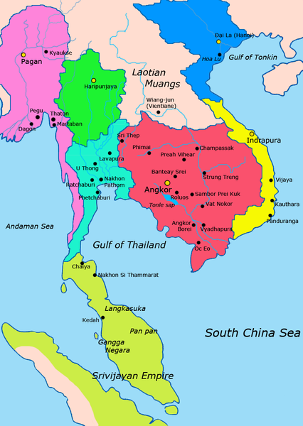
English: Map of Mainland Southeast Asia circa 1000 - 1100 CE, showing Khmer Empire in red, Lavo kingdom/Dvaravati in light blue, Haripunjaya in green, Champa in yellow, Dai Viet in blue, Kingdom of Pagan in pink, Srivijaya in lime and surrounding states.
sources http://ecaimaps.berkeley.edu/animations/2003_03_khmer_animation.swf http://www.britannica.com/EBchecked/media/3395/Khmer-empire-1200 Atlas of world history, Patrick Karl O'brien Societies, Networks, and Transitions: A Global History, Volume B. Craig A.Lockard http://upload.wikimedia.org/wikipedia/commons/thumb/4/45/Srivijaya_Empire.svg/2000px-Srivijaya_Empire.svg.png File:DvaravatiMapThailand.png http://upload.wikimedia.org/wikipedia/commons/e/eb/Thailand_2002_CIA_map.jpg |
| កាលបរិច្ឆេទ | |
| ប្រភព | ការងារផ្ទាល់របស់អ្នកផ្ទុកឡើង |
| អ្នកនិពន្ធ | Javierfv1212 |
ការដាក់អាជ្ញាប័ណ្ណ
I, the copyright holder of this work, hereby publish it under the following license:
| This file is made available under the Creative Commons CC0 1.0 Universal Public Domain Dedication. | |
| The person who associated a work with this deed has dedicated the work to the public domain by waiving all of their rights to the work worldwide under copyright law, including all related and neighboring rights, to the extent allowed by law. You can copy, modify, distribute and perform the work, even for commercial purposes, all without asking permission.
|

|
រូបភាព historical mapនេះ គួរតែបង្កើតឡើងវិញដោយប្រើក្រាភិកវ៉ិចទ័រ ដែលជាប្រភេទហ្វាល់ SVG ។ ការបង្កើតរូបភាពជាហ្វាល់ SVG ផ្តល់នូវអត្ថប្រយោជន៍ជាច្រើន។ ចំពោះព័ត៌មានបន្ថែម សូមមើល Commons:Media for cleanup ។ ប្រសិនបើទំរង់ SVG នៃរូបភាពនេះត្រូវបានបង្កើតរួចរាល់ហើយ សូមអាប់ឡូដវា។ បន្ទាប់ពីអាប់ឡូដជាទំរង់ SVG សូមជំនួសទំព័រគំរូនេះដោយ {{vector version available|ឈ្មោះរូបភាពថ្មី.svg}} ។
|
ប្រវត្តិឯកសារ
ចុចលើម៉ោងនិងកាលបរិច្ឆេទដើម្បីមើលឯកសារដែលបានផ្ទុកឡើងនៅពេលនោះ។
| ម៉ោងនិងកាលបរិច្ឆេទ | កូនរូបភាព | វិមាត្រ | អ្នកប្រើប្រាស់ | យោបល់ | |
|---|---|---|---|---|---|
| បច្ចុប្បន្ន | ម៉ោង២១:៥៧ ថ្ងៃអង្គារ ទី១៩ ខែកក្កដា ឆ្នាំ២០១១ | | ៧៩១ × ១១១៤ (១៦២គីឡូបៃ) | Ras67 | cropped |
| ម៉ោង០២:១៨ ថ្ងៃច័ន្ទ ទី២៨ ខែមីនា ឆ្នាំ២០១១ |  | ៨០០ × ១១២៥ (២២៤គីឡូបៃ) | Javierfv1212 | {{Information |Description ={{en|1=Map of Southeast Asia circa 1000 - 1100 CE, showing Khmer Empire in red, Lavo kingdom/Dvaravati in light blue, Haripunjaya in green, Champa in yellow and surrounding states. sources http://ecaimaps.berkeley.edu/an |
បម្រើបម្រាស់ឯកសារ
ទំព័រ ខាងក្រោមប្រើប្រាស់ឯកសារនេះ ៖
បម្រើបម្រាស់ឯកសារជាសាកល
វីគីដទៃទៀតដូចខាងក្រោមនេះប្រើប្រាស់ឯកសារនេះ៖
- ការប្រើប្រាស់នៅក្នុង af.wikipedia.org
- ការប្រើប្រាស់នៅក្នុង ar.wikipedia.org
- ការប្រើប្រាស់នៅក្នុង ast.wikipedia.org
- ការប្រើប្រាស់នៅក្នុង ba.wikipedia.org
- ការប្រើប្រាស់នៅក្នុង bn.wikipedia.org
- ការប្រើប្រាស់នៅក្នុង ca.wikipedia.org
- ការប្រើប្រាស់នៅក្នុង de.wikipedia.org
- ការប្រើប្រាស់នៅក្នុង el.wikipedia.org
- ការប្រើប្រាស់នៅក្នុង en.wikipedia.org
- ការប្រើប្រាស់នៅក្នុង eu.wikipedia.org
- ការប្រើប្រាស់នៅក្នុង fr.wikipedia.org
- ការប្រើប្រាស់នៅក្នុង gl.wikipedia.org
- ការប្រើប្រាស់នៅក្នុង hi.wikipedia.org
- ការប្រើប្រាស់នៅក្នុង id.wikipedia.org
- ការប្រើប្រាស់នៅក្នុង incubator.wikimedia.org
- ការប្រើប្រាស់នៅក្នុង it.wikipedia.org
- ការប្រើប្រាស់នៅក្នុង ja.wikipedia.org
- ការប្រើប្រាស់នៅក្នុង ko.wikipedia.org
- ការប្រើប្រាស់នៅក្នុង lfn.wikipedia.org
- ការប្រើប្រាស់នៅក្នុង lt.wikipedia.org
- ការប្រើប្រាស់នៅក្នុង ml.wikipedia.org
- ការប្រើប្រាស់នៅក្នុង mn.wikipedia.org
- ការប្រើប្រាស់នៅក្នុង no.wikipedia.org
- ការប្រើប្រាស់នៅក្នុង pt.wikipedia.org
- ការប្រើប្រាស់នៅក្នុង ru.wikipedia.org
- ការប្រើប្រាស់នៅក្នុង sh.wikipedia.org
- ការប្រើប្រាស់នៅក្នុង sl.wikipedia.org
- ការប្រើប្រាស់នៅក្នុង th.wikipedia.org
- ការប្រើប្រាស់នៅក្នុង uk.wikipedia.org
View more global usage of this file.