ឯកសារ:Map of Indonesia Demis.png

ទំហំរបស់ការមើលមុននេះ: ៨០០ × ៣៥៩ ភីកសែ។ ភាពម៉ត់ផ្សេងទៀត៖ ៣២០ × ១៤៤ ភីកសែ | ៦៤០ × ២៨៧ ភីកសែ | ១៤៩២ × ៦៧០ ភីកសែ។
រូបភាពដើម (១៤៩២ × ៦៧០ ភីកសែល ទំហំឯកសារ៖ ៣៤៥គីឡូបៃ ប្រភេទ MIME៖ image/png)
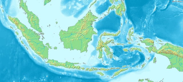
Map of Indonesia
Bounding box West 93°, South -12°, East 142°, North 10°. Center at 1°00′00″S 117°30′00″E / 1.00000°S 117.50000°E.
This image is in the public domain because it came from the site https://www.demis.nl/products/web-map-server/examples/ and was released by the copyright holder. Permission is granted to copy, distribute and/or modify this map since it is based on free of copyright images from: www.demis.nl. See also approval email on de.wp and its clarification.
|
| This work has been released into the public domain by its copyright holder, www.demis.nl. This applies worldwide. In some countries this may not be legally possible; if so: www.demis.nl grants anyone the right to use this work for any purpose, without any conditions, unless such conditions are required by law.
|
ប្រវត្តិឯកសារ
ចុចលើម៉ោងនិងកាលបរិច្ឆេទដើម្បីមើលឯកសារដែលបានផ្ទុកឡើងនៅពេលនោះ។
| ម៉ោងនិងកាលបរិច្ឆេទ | កូនរូបភាព | វិមាត្រ | អ្នកប្រើប្រាស់ | យោបល់ | |
|---|---|---|---|---|---|
| បច្ចុប្បន្ន | ម៉ោង១៧:៤៨ ថ្ងៃពុធ ទី២០ ខែធ្នូ ឆ្នាំ២០០៦ | | ១៤៩២ × ៦៧០ (៣៤៥គីឡូបៃ) | Mats Halldin~commonswiki | Map of Indonesia Bounding box West 93°, South -12°, East 142°, North 10°. Center at {{coor d|1.00000|S|117.50000|E|scale:13200000}}. {{demis-pd}} Category:Maps of Indonesia |
បម្រើបម្រាស់ឯកសារ
ទំព័រ ខាងក្រោមប្រើប្រាស់ឯកសារនេះ ៖
បម្រើបម្រាស់ឯកសារជាសាកល
វីគីដទៃទៀតដូចខាងក្រោមនេះប្រើប្រាស់ឯកសារនេះ៖
- ការប្រើប្រាស់នៅក្នុង ar.wikipedia.org
- ការប្រើប្រាស់នៅក្នុង bg.wikipedia.org
- ការប្រើប្រាស់នៅក្នុង bn.wikipedia.org
- ការប្រើប្រាស់នៅក្នុង es.wikipedia.org
- ការប្រើប្រាស់នៅក្នុង et.wikipedia.org
- ការប្រើប្រាស់នៅក្នុង eu.wikipedia.org
- ការប្រើប្រាស់នៅក្នុង fr.wikipedia.org
- ការប្រើប្រាស់នៅក្នុង hr.wikipedia.org
- ការប្រើប្រាស់នៅក្នុង hy.wikipedia.org
- ការប្រើប្រាស់នៅក្នុង id.wikipedia.org
- ការប្រើប្រាស់នៅក្នុង ja.wikipedia.org
- ការប្រើប្រាស់នៅក្នុង ko.wikipedia.org
- ការប្រើប្រាស់នៅក្នុង la.wikipedia.org
- ការប្រើប្រាស់នៅក្នុង nl.wikipedia.org
- ការប្រើប្រាស់នៅក្នុង pl.wikipedia.org
- ការប្រើប្រាស់នៅក្នុង pnb.wikipedia.org
- ការប្រើប្រាស់នៅក្នុង sq.wikipedia.org
- ការប្រើប្រាស់នៅក្នុង uk.wikipedia.org
- ការប្រើប្រាស់នៅក្នុង vep.wikipedia.org
- ការប្រើប្រាស់នៅក្នុង vi.wikipedia.org