ឯកសារ:Map of Vietnam 1829.jpg
ទំហំរបស់ការមើលមុននេះ: ៣៩៩ × ៥៩៩ ភីកសែ។ ភាពម៉ត់ផ្សេងទៀត៖ ១៦០ × ២៤០ ភីកសែ | ៣២០ × ៤៨០ ភីកសែ | ៥១១ × ៧៦៨ ភីកសែ | ៦៨២ × ១០២៤ ភីកសែ | ១៣៦៤ × ២០៤៨ ភីកសែ | ៣៤៦៤ × ៥២០០ ភីកសែ។
រូបភាពដើម (៣៤៦៤ × ៥២០០ ភីកសែល ទំហំឯកសារ៖ ៨.៨៣មេកាបៃ ប្រភេទ MIME៖ image/jpeg)
ចំណារពន្យល់
| ការពិពណ៌នា |
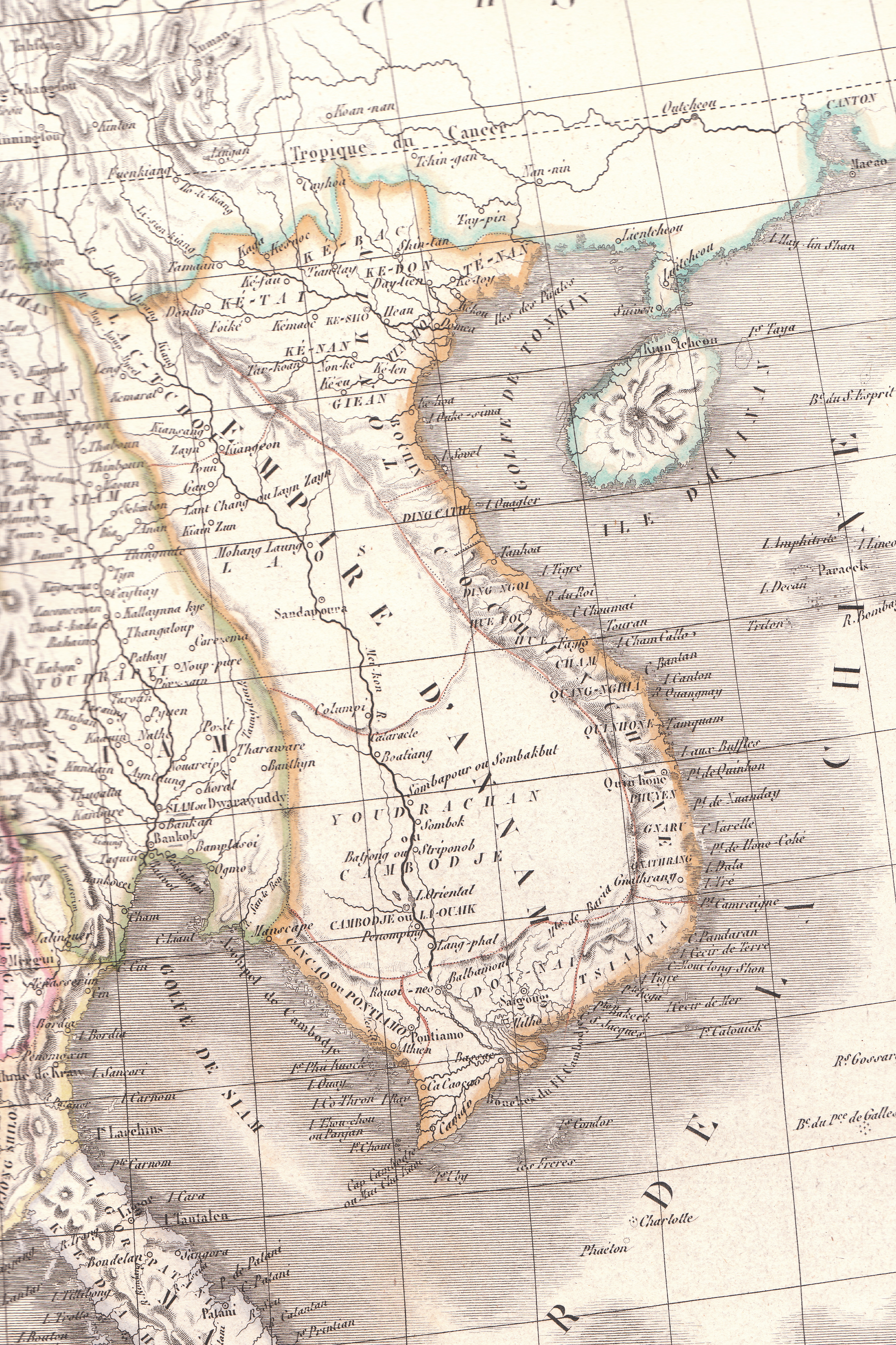
English: Plate 35E "Carte de l’Inde endeca et audela du Gange" from Lapie's Atlas Universel printed in 1829 |
| ប្រភព | Atlas Universel |
| អ្នកនិពន្ធ | Pierre M. Lapie |
ការដាក់អាជ្ញាប័ណ្ណ
|
This work is in the public domain in its country of origin and other countries and areas where the copyright term is the author's life plus 70 years or fewer. This work is in the public domain in the United States because it was published (or registered with the U.S. Copyright Office) before January 1, 1929. | |
| This file has been identified as being free of known restrictions under copyright law, including all related and neighboring rights. | |
ប្រវត្តិឯកសារ
ចុចលើម៉ោងនិងកាលបរិច្ឆេទដើម្បីមើលឯកសារដែលបានផ្ទុកឡើងនៅពេលនោះ។
| ម៉ោងនិងកាលបរិច្ឆេទ | កូនរូបភាព | វិមាត្រ | អ្នកប្រើប្រាស់ | យោបល់ | |
|---|---|---|---|---|---|
| បច្ចុប្បន្ន | ម៉ោង០៦:២៣ ថ្ងៃច័ន្ទ ទី២៦ ខែមេសា ឆ្នាំ២០១០ | | ៣៤៦៤ × ៥២០០ (៨.៨៣មេកាបៃ) | Duyet-pho | {{Information |Description={{en|1=Plate 35E "Carte de l’Inde endeca et audela du Gange" from Lapie's ''Atlas Universel'' printed in 1829}} |Source=Atlas Universel |Author=Pierre M. Lapie |Date= |Permission={{PD-1923}} |other_versions= }} [[Category:Map |
បម្រើបម្រាស់ឯកសារ
គ្មានទំព័រណាមួយដែលប្រើប្រាស់ឯកសារនេះទេ។
បម្រើបម្រាស់ឯកសារជាសាកល
វីគីដទៃទៀតដូចខាងក្រោមនេះប្រើប្រាស់ឯកសារនេះ៖
- ការប្រើប្រាស់នៅក្នុង ca.wikipedia.org
- ការប្រើប្រាស់នៅក្នុង en.wikipedia.org
- ការប្រើប្រាស់នៅក្នុង eu.wikipedia.org
- ការប្រើប្រាស់នៅក្នុង gl.wikipedia.org
- ការប្រើប្រាស់នៅក្នុង id.wikipedia.org
- ការប្រើប្រាស់នៅក្នុង it.wikipedia.org
- ការប្រើប្រាស់នៅក្នុង pt.wikipedia.org
- ការប្រើប្រាស់នៅក្នុង ru.wikipedia.org
- ការប្រើប្រាស់នៅក្នុង th.wikipedia.org
- ការប្រើប្រាស់នៅក្នុង tr.wikipedia.org
- ការប្រើប្រាស់នៅក្នុង vi.wikipedia.org
- ការប្រើប្រាស់នៅក្នុង www.wikidata.org
- ការប្រើប្រាស់នៅក្នុង zh-min-nan.wikipedia.org
- ការប្រើប្រាស់នៅក្នុង zh-yue.wikipedia.org