ឯកសារ:North Korea Topography.png

ទំហំរបស់ការមើលមុននេះ: ៥៨៣ × ៥៩៩ ភីកសែ។ ភាពម៉ត់ផ្សេងទៀត៖ ២៣៣ × ២៤០ ភីកសែ | ៤៦៧ × ៤៨០ ភីកសែ | ៧៤៧ × ៧៦៨ ភីកសែ | ៩៩៦ × ១០២៤ ភីកសែ | ១៧០៥ × ១៧៥៣ ភីកសែ។
រូបភាពដើម (១៧០៥ × ១៧៥៣ ភីកសែល ទំហំឯកសារ៖ ៣.៥៦មេកាបៃ ប្រភេទ MIME៖ image/png)
ចំណារពន្យល់
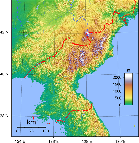
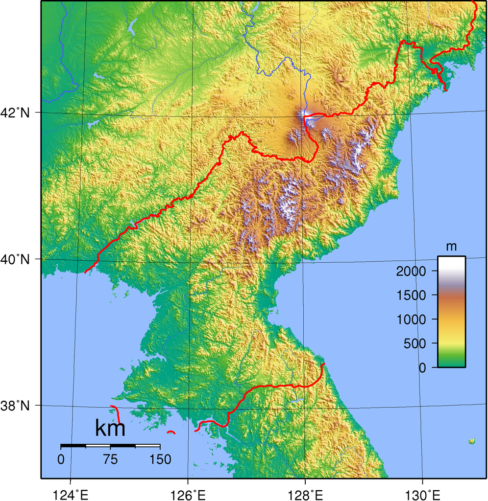
| ការពិពណ៌នា | Topographic map of the territory claimed by North Korea. Created with GMT from SRTM data. |
| កាលបរិច្ឆេទ | |
| ប្រភព | ការងារផ្ទាល់របស់អ្នកផ្ទុកឡើង |
| អ្នកនិពន្ធ | Sadalmelik |
| ទំរង់ផ្សេងទៀត | Derivative works of this file: Chilbo-san North Korea.jpg |
ការដាក់អាជ្ញាប័ណ្ណ
I, the copyright holder of this work, hereby publish it under the following licenses:

|
រូបភាពនៃទំព័រនេះជាកម្មសិទ្ធិរបស់GNU Free Documentation License។ Version 1.2 ឬក៏ខ្ពស់ជាងនេះត្រូវបានឧបត្ថមគាំទ្រដោយ មូលនិធិសូហ្វវែរដោយឥតគិតថ្លៃ (Free Software Foundation) ដែលមិនមានផ្នែកណាមួយរបស់ប្រភពដើមរួមទាំងអក្សរនៅលើគំរបមុខនិងខ្នង ត្រូវបានផ្លាស់ប្តូរទេ។ ចំពោះផ្នែកដែលមិនអាចផ្លាស់ប្តូរបាន សូមមើលGNU Free Documentation License។ |
ឯកសារនេះជាប់អាជ្ញាបណ្ឌCreative Commons Attribution-Share Alike 3.0 Unported, 2.5 Generic, 2.0 Generic និង 1.0 Generic។
- អ្នកមានសិទ្ធិ៖
- ចែកចាយ – ថតចំលងនិងចែកចាយស្នាដៃនេះ
- កែច្នៃ – កែច្នៃយកទៅប្រើ
- ក្រោមលក្ខខណ្ឌដូចតទៅនេះ៖
- ភាពជាម្ចាស់កម្មសិទ្ធ – You must give appropriate credit, provide a link to the license, and indicate if changes were made. You may do so in any reasonable manner, but not in any way that suggests the licensor endorses you or your use.
- share alike – If you remix, transform, or build upon the material, you must distribute your contributions under the same or compatible license as the original.
You may select the license of your choice.
흐화ㅐ ㅜㅜ 할45분
ប្រវត្តិឯកសារ
ចុចលើម៉ោងនិងកាលបរិច្ឆេទដើម្បីមើលឯកសារដែលបានផ្ទុកឡើងនៅពេលនោះ។
| ម៉ោងនិងកាលបរិច្ឆេទ | កូនរូបភាព | វិមាត្រ | អ្នកប្រើប្រាស់ | យោបល់ | |
|---|---|---|---|---|---|
| បច្ចុប្បន្ន | ម៉ោង១៧:៤៨ ថ្ងៃសៅរ៍ ទី០១ ខែកញ្ញា ឆ្នាំ២០០៧ | | ១៧០៥ × ១៧៥៣ (៣.៥៦មេកាបៃ) | Sadalmelik | {{Information |Description=Topographic map of North Korea. Created wth GMT from SRTM data. |Source=self-made |Date=Sep 1, 2007 |Author= Sadalmelik }} Category:Topographic maps of Asia Category:Maps of North Korea |
បម្រើបម្រាស់ឯកសារ
ទំព័រ ខាងក្រោមប្រើប្រាស់ឯកសារនេះ ៖
បម្រើបម្រាស់ឯកសារជាសាកល
វីគីដទៃទៀតដូចខាងក្រោមនេះប្រើប្រាស់ឯកសារនេះ៖
- ការប្រើប្រាស់នៅក្នុង ang.wikipedia.org
- ការប្រើប្រាស់នៅក្នុង ar.wikipedia.org
- ការប្រើប្រាស់នៅក្នុង ast.wikipedia.org
- ការប្រើប្រាស់នៅក្នុង bbc.wikipedia.org
- ការប្រើប្រាស់នៅក្នុង be.wikipedia.org
- ការប្រើប្រាស់នៅក្នុង bg.wikipedia.org
- ការប្រើប្រាស់នៅក្នុង bn.wikipedia.org
- ការប្រើប្រាស់នៅក្នុង cy.wikipedia.org
- ការប្រើប្រាស់នៅក្នុង el.wikipedia.org
- ការប្រើប្រាស់នៅក្នុង en.wikipedia.org
- ការប្រើប្រាស់នៅក្នុង es.wikipedia.org
- ការប្រើប្រាស់នៅក្នុង eu.wikipedia.org
- ការប្រើប្រាស់នៅក្នុង fi.wikipedia.org
- ការប្រើប្រាស់នៅក្នុង fi.wikibooks.org
- ការប្រើប្រាស់នៅក្នុង fr.wikipedia.org
- ការប្រើប្រាស់នៅក្នុង ha.wikipedia.org
- ការប្រើប្រាស់នៅក្នុង he.wikipedia.org
- ការប្រើប្រាស់នៅក្នុង hr.wikipedia.org
- ការប្រើប្រាស់នៅក្នុង hu.wikipedia.org
- ការប្រើប្រាស់នៅក្នុង id.wikipedia.org
- ការប្រើប្រាស់នៅក្នុង it.wikipedia.org
- ការប្រើប្រាស់នៅក្នុង ja.wikipedia.org
- ការប្រើប្រាស់នៅក្នុង kn.wikipedia.org
- ការប្រើប្រាស់នៅក្នុង ko.wikipedia.org
- ការប្រើប្រាស់នៅក្នុង li.wikipedia.org
- ការប្រើប្រាស់នៅក្នុង mai.wikipedia.org
- ការប្រើប្រាស់នៅក្នុង mk.wikipedia.org
- ការប្រើប្រាស់នៅក្នុង mn.wikipedia.org
- ការប្រើប្រាស់នៅក្នុង ms.wikipedia.org
- ការប្រើប្រាស់នៅក្នុង mt.wikipedia.org
- ការប្រើប្រាស់នៅក្នុង no.wikipedia.org
- ការប្រើប្រាស់នៅក្នុង pl.wikipedia.org
- ការប្រើប្រាស់នៅក្នុង pt.wikipedia.org
- ការប្រើប្រាស់នៅក្នុង ru.wikipedia.org
View more global usage of this file.