ឯកសារ:Satellite image of Hokkaido, Japan in January 2003.jpg

ទំហំរបស់ការមើលមុននេះ: ៤៧១ × ៥៩៩ ភីកសែ។ ភាពម៉ត់ផ្សេងទៀត៖ ១៨៨ × ២៤០ ភីកសែ | ៣៧៧ × ៤៨០ ភីកសែ | ៦០៣ × ៧៦៨ ភីកសែ | ៨០៤ × ១០២៤ ភីកសែ | ២២០០ × ២៨០០ ភីកសែ។
រូបភាពដើម (២២០០ × ២៨០០ ភីកសែល ទំហំឯកសារ៖ ១.៧៤មេកាបៃ ប្រភេទ MIME៖ image/jpeg)
ចំណារពន្យល់
ចំណារពន្យល់
| ការពិពណ៌នា |
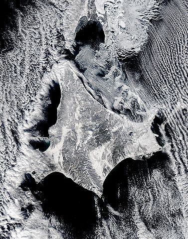
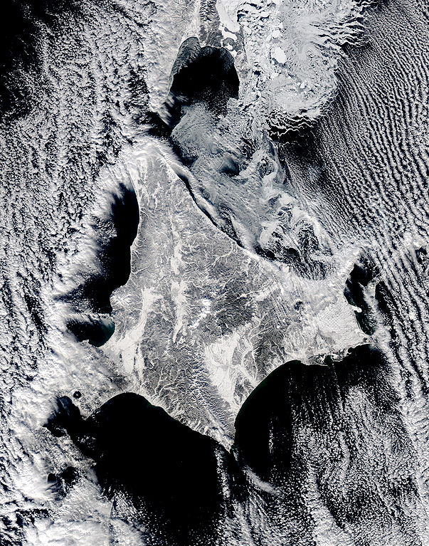
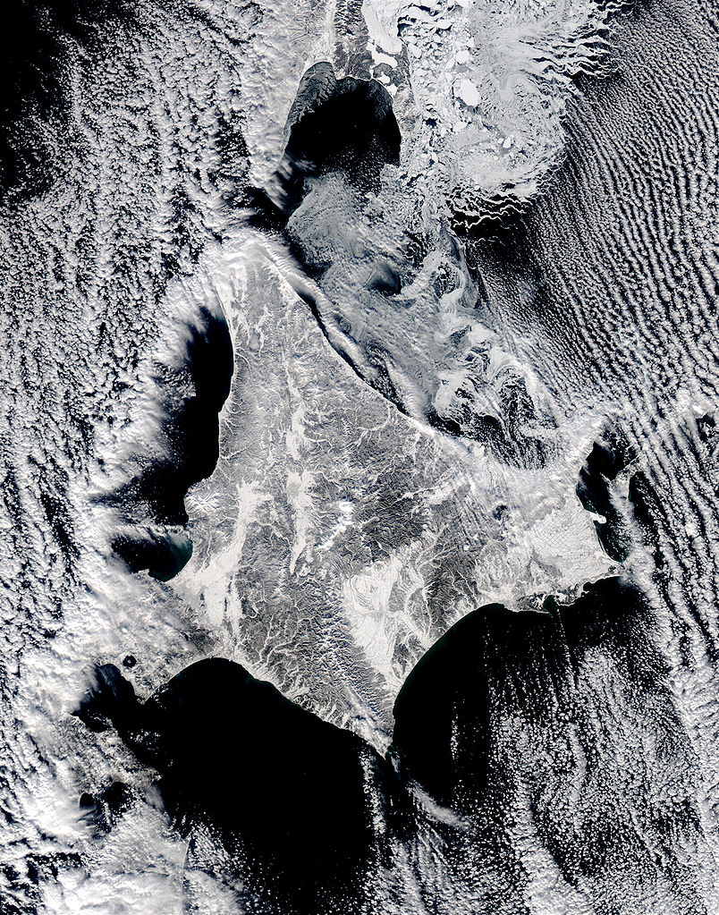
English: Satellite image of Hokkaido, Japan in January 2003. This stunning true-color image shows clouds surrounding northern Japan’s snow-dusted Hokkaido Island in between the black waters of two seas and an ocean. Hokkaido Island is home to the city of Sapporo, which is located on the lower western side near where the island’s tail begins to curve south toward the main island of Japan (middle lower left) and not far from the Ishikari-wan, the north-facing bay that has a streak of clouds moving horizontally across it. Hokkaido’s northern point reaches toward the Russian island of Sakhalin (top center), while the eastern point stretches toward the Kuril Islands, a volcanic chain that eventually connects to the Russian Kamchatka Peninsula. Between Hokkaido’s northern and eastern points lies the southern reaches of the Sea of Okhotsk (upper right), while the northern and southern points lie along the Sea of Japan. From its southern to eastern point, the Pacific Ocean laps at Hokkaido’s shores. This Aqua MODIS image was acquired January 15, 2003. |
| កាលបរិច្ឆេទ | |
| ប្រភព | NASA's Visible Earth http://visibleearth.nasa.gov/view_rec.php?id=4720 |
| អ្នកនិពន្ធ | NASA's Visible Earth |
ការដាក់អាជ្ញាប័ណ្ណ
| This file is in the public domain in the United States because it was solely created by NASA. NASA copyright policy states that "NASA material is not protected by copyright unless noted". (See Template:PD-USGov, NASA copyright policy page or JPL Image Use Policy.) | ||
 |
Warnings:
|
ប្រវត្តិឯកសារ
ចុចលើម៉ោងនិងកាលបរិច្ឆេទដើម្បីមើលឯកសារដែលបានផ្ទុកឡើងនៅពេលនោះ។
| ម៉ោងនិងកាលបរិច្ឆេទ | កូនរូបភាព | វិមាត្រ | អ្នកប្រើប្រាស់ | យោបល់ | |
|---|---|---|---|---|---|
| បច្ចុប្បន្ន | ម៉ោង២២:០២ ថ្ងៃអាទិត្យ ទី០៧ ខែឧសភា ឆ្នាំ២០០៦ | | ២២០០ × ២៨០០ (១.៧៤មេកាបៃ) | Akanemoto~commonswiki | Satellite image of Hokkaido, Japan in January 2003. Taken from NASA's Visible Earth http://visibleearth.nasa.gov/view_rec.php?id=4720 : This stunning true-color image shows clouds surrounding northern Japan’s snow-dusted Hokkaido Island in between the |
បម្រើបម្រាស់ឯកសារ
ទំព័រ ខាងក្រោមប្រើប្រាស់ឯកសារនេះ ៖
បម្រើបម្រាស់ឯកសារជាសាកល
វីគីដទៃទៀតដូចខាងក្រោមនេះប្រើប្រាស់ឯកសារនេះ៖
- ការប្រើប្រាស់នៅក្នុង ast.wikipedia.org
- ការប្រើប្រាស់នៅក្នុង az.wikipedia.org
- ការប្រើប្រាស់នៅក្នុង ba.wikipedia.org
- ការប្រើប្រាស់នៅក្នុង en.wikipedia.org
- ការប្រើប្រាស់នៅក្នុង es.wikipedia.org
- ការប្រើប្រាស់នៅក្នុង id.wikipedia.org
- ការប្រើប្រាស់នៅក្នុង it.wikipedia.org
- ការប្រើប្រាស់នៅក្នុង ja.wikipedia.org
- ការប្រើប្រាស់នៅក្នុង pam.wikipedia.org
- ការប្រើប្រាស់នៅក្នុង pt.wikipedia.org
- ការប្រើប្រាស់នៅក្នុង ru.wikinews.org
- ការប្រើប្រាស់នៅក្នុង tg.wikipedia.org
- ការប្រើប្រាស់នៅក្នុង vi.wikipedia.org