ឯកសារ:Scotland location map.svg

Size of this PNG preview of this SVG file: ៤៥៦ × ៦០០ ភីកសែ. ភាពម៉ត់ផ្សេងទៀត៖ ១៨២ × ២៤០ ភីកសែ | ៣៦៥ × ៤៨០ ភីកសែ | ៥៨៤ × ៧៦៨ ភីកសែ | ៧៧៩ × ១០២៤ ភីកសែ | ១៥៥៨ × ២០៤៨ ភីកសែ | ១១២៨ × ១៤៨៣ ភីកសែ។
រូបភាពដើម (ឯកសារប្រភេទSVG ១១២៨ × ១៤៨៣ ភីកសែល ទំហំឯកសារ៖ ៨១០គីឡូបៃ)
ចំណារពន្យល់
| ការពិពណ៌នា |
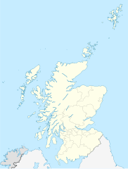
Quadratische Plattkarte, N-S-Streckung 170 %. Geographische Begrenzung der Karte:
Equirectangular projection, N/S stretching 170 %. Geographic limits of the map:
|
||
| កាលបរិច្ឆេទ | ៩ ខែតុលា ២០០៨ (upload date) | ||
| ប្រភព |
own work, using
|
||
| អ្នកនិពន្ធ | NordNordWest | ||
| ទំរង់ផ្សេងទៀត |
Derivative works of this file:
|
||
| SVG genesis | រូបភាពក្រាភិកវ៉ិចទ័រនេះត្រូវបានបង្កើតឡើងដោយប្រើ Inkscape.
|


ការដាក់អាជ្ញាប័ណ្ណ
I, the copyright holder of this work, hereby publish it under the following licenses:

|
រូបភាពនៃទំព័រនេះជាកម្មសិទ្ធិរបស់GNU Free Documentation License។ Version 1.2 ឬក៏ខ្ពស់ជាងនេះត្រូវបានឧបត្ថមគាំទ្រដោយ មូលនិធិសូហ្វវែរដោយឥតគិតថ្លៃ (Free Software Foundation) ដែលមិនមានផ្នែកណាមួយរបស់ប្រភពដើមរួមទាំងអក្សរនៅលើគំរបមុខនិងខ្នង ត្រូវបានផ្លាស់ប្តូរទេ។ ចំពោះផ្នែកដែលមិនអាចផ្លាស់ប្តូរបាន សូមមើលGNU Free Documentation License។ |
ឯកសារនេះជាប់អាជ្ញាបណ្ឌCreative Commons Attribution-Share Alike 3.0 Unported។
ភាពជាម្ចាស់កម្មសិទ្ធ: Eric Gaba, NordNordWest
- អ្នកមានសិទ្ធិ៖
- ចែកចាយ – ថតចំលងនិងចែកចាយស្នាដៃនេះ
- កែច្នៃ – កែច្នៃយកទៅប្រើ
- ក្រោមលក្ខខណ្ឌដូចតទៅនេះ៖
- ភាពជាម្ចាស់កម្មសិទ្ធ – You must give appropriate credit, provide a link to the license, and indicate if changes were made. You may do so in any reasonable manner, but not in any way that suggests the licensor endorses you or your use.
- share alike – If you remix, transform, or build upon the material, you must distribute your contributions under the same or compatible license as the original.
You may select the license of your choice.
ប្រវត្តិឯកសារ
ចុចលើម៉ោងនិងកាលបរិច្ឆេទដើម្បីមើលឯកសារដែលបានផ្ទុកឡើងនៅពេលនោះ។
| ម៉ោងនិងកាលបរិច្ឆេទ | កូនរូបភាព | វិមាត្រ | អ្នកប្រើប្រាស់ | យោបល់ | |
|---|---|---|---|---|---|
| បច្ចុប្បន្ន | ម៉ោង១៨:២៧ ថ្ងៃព្រហស្បតិ៍ ទី០៩ ខែតុលា ឆ្នាំ២០០៨ | | ១១២៨ × ១៤៨៣ (៨១០គីឡូបៃ) | NordNordWest | {{Information |Description= {{de|Positionskarte von Schottland, Vereinigtes Königreich}} Quadratische Plattkarte, N-S-Streckung 170 %. Geographische Begrenzung der Karte: * N: 61.0° N * S: 54.5° N * W: |
បម្រើបម្រាស់ឯកសារ
ទំព័រ ខាងក្រោមប្រើប្រាស់ឯកសារនេះ ៖
បម្រើបម្រាស់ឯកសារជាសាកល
វីគីដទៃទៀតដូចខាងក្រោមនេះប្រើប្រាស់ឯកសារនេះ៖
- ការប្រើប្រាស់នៅក្នុង ab.wikipedia.org
- ការប្រើប្រាស់នៅក្នុង af.wikipedia.org
- Gebruiker:Laurens
- Rugbywêreldbeker 2007
- Skerryvore
- Sjabloon:Liggingkaart Skotland
- Aberdeen (dubbelsinnig)
- Auchtermuchty
- Inverness
- Kirkwall
- Gruinard-eiland
- Lockerbie
- Ben Nevis
- Skara Brae
- Govan
- Verenigde Rugbykampioenskap
- Aberfoyle, Stirling
- Alloway
- Skotse nasionale krieketspan
- Dumfries
- Glen Coe
- Bonnybridge
- Ayr
- Luss
- ការប្រើប្រាស់នៅក្នុង ar.wikipedia.org
- ការប្រើប្រាស់នៅក្នុង arz.wikipedia.org
- ការប្រើប្រាស់នៅក្នុង ast.wikipedia.org
- ការប្រើប្រាស់នៅក្នុង azb.wikipedia.org
View more global usage of this file.