ឯកសារ:Somerset UK location map.svg

Size of this PNG preview of this SVG file: ៨០០ × ៥០៦ ភីកសែ. ភាពម៉ត់ផ្សេងទៀត៖ ៣២០ × ២០២ ភីកសែ | ៦៤០ × ៤០៥ ភីកសែ | ១០២៤ × ៦៤៧ ភីកសែ | ១២៨០ × ៨០៩ ភីកសែ | ២៥៦០ × ១៦១៩ ភីកសែ | ១៤២៥ × ៩០១ ភីកសែ។
រូបភាពដើម (ឯកសារប្រភេទSVG ១៤២៥ × ៩០១ ភីកសែល ទំហំឯកសារ៖ ២.៣៨មេកាបៃ)
| ការពិពណ៌នា |
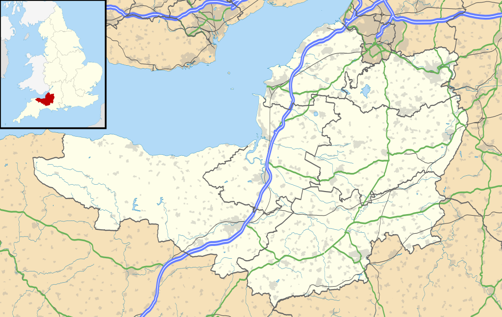
Map of Somerset, UK with the following information shown:
Equirectangular map projection on WGS 84 datum, with N/S stretched 155% Geographic limits:
|
| កាលបរិច្ឆេទ | |
| ប្រភព |
|
| អ្នកនិពន្ធ | Nilfanion, created using Ordnance Survey data |
| ការអនុញ្ញាត (ប្រើឯកសារនេះឡើងវិញ) |
ឯកសារនេះជាប់អាជ្ញាបណ្ឌCreative Commons Attribution-Share Alike 3.0 Unported។ ភាពជាម្ចាស់កម្មសិទ្ធ: Contains Ordnance Survey data © Crown copyright and database right
|
| ទំរង់ផ្សេងទៀត | File:Somerset UK district map (blank).svg - Blank map |
.svg)
ប្រវត្តិឯកសារ
ចុចលើម៉ោងនិងកាលបរិច្ឆេទដើម្បីមើលឯកសារដែលបានផ្ទុកឡើងនៅពេលនោះ។
| ម៉ោងនិងកាលបរិច្ឆេទ | កូនរូបភាព | វិមាត្រ | អ្នកប្រើប្រាស់ | យោបល់ | |
|---|---|---|---|---|---|
| បច្ចុប្បន្ន | ម៉ោង១៩:២៣ ថ្ងៃសុក្រ ទី១៧ ខែមករា ឆ្នាំ២០២០ | | ១៤២៥ × ៩០១ (២.៣៨មេកាបៃ) | The Equalizer | Updated district borders (Somerset West and Taunton) |
| ម៉ោង១៩:១២ ថ្ងៃអាទិត្យ ទី២៦ ខែកញ្ញា ឆ្នាំ២០១០ |  | ១៤២៥ × ៩០១ (២.៣៦មេកាបៃ) | Nilfanion | {{Information |Description=Map of Somerset, UK with the following information shown: *Administrative borders *Coastline, lakes and rivers *Roads and railways *Urban areas Equirectangular map projection on WGS 84 datum, with N/S stretched 1 |
បម្រើបម្រាស់ឯកសារ
3 ទំព័រ ខាងក្រោមប្រើប្រាស់ឯកសារនេះ ៖
បម្រើបម្រាស់ឯកសារជាសាកល
វីគីដទៃទៀតដូចខាងក្រោមនេះប្រើប្រាស់ឯកសារនេះ៖
- ការប្រើប្រាស់នៅក្នុង ar.wikipedia.org
- ការប្រើប្រាស់នៅក្នុង arz.wikipedia.org
- ការប្រើប្រាស់នៅក្នុង bg.wikipedia.org
- ការប្រើប្រាស់នៅក្នុង bh.wikipedia.org
- ការប្រើប្រាស់នៅក្នុង bn.wikipedia.org
- টেমপ্লেট:তথ্যছক ঐতিহাসিক স্থান
- ডানস্টারের চলমান ওয়াটারমিল
- স্টোনি লিটলটন লং ব্যারৌ
- ট্রেজারস হাউজ
- ব্ল্যাকফোর্ড ফার্মের পায়রার বাসা
- ডানস্টের বাটার ক্রুশ
- টিনটিনহাল বাগান
- টেমপ্লেট:তথ্যছক বিশেষ বৈজ্ঞানিক আগ্রহের সাইট
- মডিউল:অবস্থান মানচিত্র/উপাত্ত/যুক্তরাজ্য সমারসেট
- মডিউল:অবস্থান মানচিত্র/উপাত্ত/যুক্তরাজ্য সমারসেট/নথি
- মডিউল:অবস্থান মানচিত্র/উপাত্ত/সমারসেট
- মডিউল:অবস্থান মানচিত্র/উপাত্ত/সমারসেট/নথি
- টেমপ্লেট:তথ্যছক বিশেষ বৈজ্ঞানিক আগ্রহের সাইট/নথি
- টেমপ্লেট:তথ্যছক ঐতিহাসিক স্থান/নথি
- ব্রিস্টল বিমানবন্দর
- মডিউল:অবস্থান মানচিত্র/উপাত্ত/সোমারসেট
- মডিউল:অবস্থান মানচিত্র/উপাত্ত/সোমারসেট/নথি
- ការប្រើប្រាស់នៅក្នុង ceb.wikipedia.org
- ការប្រើប្រាស់នៅក្នុង dty.wikipedia.org
- ការប្រើប្រាស់នៅក្នុង en.wikipedia.org
- Cheddar, Somerset
- Wookey Hole Caves
- Bath, Somerset
- Wells, Somerset
- Bridgwater
- Glastonbury
- Shepton Mallet
- Bath Abbey
- Glastonbury Festival
- American Museum and Gardens
- Glastonbury Tor
- Nether Stowey
- Street, Somerset
- Sieges of Taunton
- Taunton
- Athelney
- North Petherton
- Bridgwater Bay
- Puriton
- Weston-super-Mare
- Yeovil
- Frome
- Clevedon
- Solsbury Hill
View more global usage of this file.