ឯកសារ:Vietnam1650.GIF
ទំហំរបស់ការមើលមុននេះ: ៣៦០ × ៦០០ ភីកសែ។ ភាពម៉ត់ផ្សេងទៀត៖ ១៤៤ × ២៤០ ភីកសែ | ៤២៨ × ៧១៣ ភីកសែ។
រូបភាពដើម (៤២៨ × ៧១៣ ភីកសែល ទំហំឯកសារ៖ ១៥គីឡូបៃ ប្រភេទ MIME៖ image/gif)
ចំណារពន្យល់
| ការពិពណ៌នា |
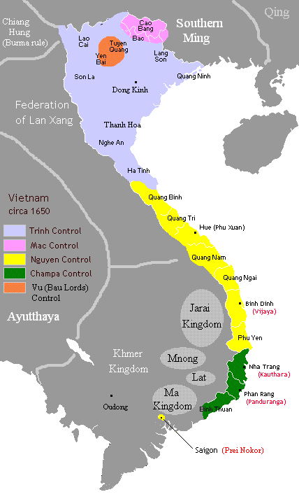
English: More accurate borders in 1650: Trinh Nguyen border at Giang river. Bau Lords still hold out at Yen Bai and Tuyen Quang provinces. Champa as rump states of Hoa Anh and Panduranga still hold out at today's Khanh Hoa province. |
|||||
| កាលបរិច្ឆេទ | ||||||
| ប្រភព | Own work based on Gryffindor's map | |||||
| អ្នកនិពន្ធ | Own work by uploader | |||||
| ការអនុញ្ញាត (ប្រើឯកសារនេះឡើងវិញ) |
I, the copyright holder of this work, hereby publish it under the following licenses:
ឯកសារនេះជាប់អាជ្ញាបណ្ឌCreative Commons Attribution 2.5 Generic។
You may select the license of your choice. |

ការដាក់អាជ្ញាប័ណ្ណ
| I, the copyright holder of this work, release this work into the public domain. This applies worldwide. In some countries this may not be legally possible; if so: I grant anyone the right to use this work for any purpose, without any conditions, unless such conditions are required by law. |

|
រូបភាព historical mapនេះ គួរតែបង្កើតឡើងវិញដោយប្រើក្រាភិកវ៉ិចទ័រ ដែលជាប្រភេទហ្វាល់ SVG ។ ការបង្កើតរូបភាពជាហ្វាល់ SVG ផ្តល់នូវអត្ថប្រយោជន៍ជាច្រើន។ ចំពោះព័ត៌មានបន្ថែម សូមមើល Commons:Media for cleanup ។ ប្រសិនបើទំរង់ SVG នៃរូបភាពនេះត្រូវបានបង្កើតរួចរាល់ហើយ សូមអាប់ឡូដវា។ បន្ទាប់ពីអាប់ឡូដជាទំរង់ SVG សូមជំនួសទំព័រគំរូនេះដោយ {{vector version available|ឈ្មោះរូបភាពថ្មី.svg}} ។
|
ប្រវត្តិឯកសារ
ចុចលើម៉ោងនិងកាលបរិច្ឆេទដើម្បីមើលឯកសារដែលបានផ្ទុកឡើងនៅពេលនោះ។
| ម៉ោងនិងកាលបរិច្ឆេទ | កូនរូបភាព | វិមាត្រ | អ្នកប្រើប្រាស់ | យោបល់ | |
|---|---|---|---|---|---|
| បច្ចុប្បន្ន | ម៉ោង០៦:២៥ ថ្ងៃច័ន្ទ ទី០១ ខែមេសា ឆ្នាំ២០១៣ | | ៤២៨ × ៧១៣ (១៥គីឡូបៃ) | Sgnpkd | {{Information |Description ={{en|1=More accurate borders in 1650: Trinh Nguyen border at Giang river. Bau Lords still hold out at Yen Bai and Tuyen Quang provinces. Champa as rump states of Hoa Anh and Panduranga still hold out at today's Khanh Hoa ... |
បម្រើបម្រាស់ឯកសារ
3 ទំព័រ ខាងក្រោមប្រើប្រាស់ឯកសារនេះ ៖
បម្រើបម្រាស់ឯកសារជាសាកល
វីគីដទៃទៀតដូចខាងក្រោមនេះប្រើប្រាស់ឯកសារនេះ៖
- ការប្រើប្រាស់នៅក្នុង ar.wikipedia.org
- ការប្រើប្រាស់នៅក្នុង ba.wikipedia.org
- ការប្រើប្រាស់នៅក្នុង bn.wikipedia.org
- ការប្រើប្រាស់នៅក្នុង ceb.wikipedia.org
- ការប្រើប្រាស់នៅក្នុង da.wikipedia.org
- ការប្រើប្រាស់នៅក្នុង de.wikipedia.org
- ការប្រើប្រាស់នៅក្នុង en.wikipedia.org
- ការប្រើប្រាស់នៅក្នុង fi.wikipedia.org
- ការប្រើប្រាស់នៅក្នុង fr.wikipedia.org
- ការប្រើប្រាស់នៅក្នុង he.wikipedia.org
- ការប្រើប្រាស់នៅក្នុង id.wikipedia.org
- ការប្រើប្រាស់នៅក្នុង it.wikipedia.org
- ការប្រើប្រាស់នៅក្នុង ja.wikipedia.org
- ការប្រើប្រាស់នៅក្នុង ko.wikipedia.org
- ការប្រើប្រាស់នៅក្នុង no.wikipedia.org
- ការប្រើប្រាស់នៅក្នុង pt.wikipedia.org
- ការប្រើប្រាស់នៅក្នុង ru.wikipedia.org
- ការប្រើប្រាស់នៅក្នុង sl.wikipedia.org
- ការប្រើប្រាស់នៅក្នុង sv.wikipedia.org
- ការប្រើប្រាស់នៅក្នុង th.wikipedia.org
- ការប្រើប្រាស់នៅក្នុង uk.wikipedia.org
View more global usage of this file.