ឯកសារ:Western Han Mawangdui Silk Map.JPG

ទំហំរបស់ការមើលមុននេះ: ៦២១ × ៦០០ ភីកសែ។ ភាពម៉ត់ផ្សេងទៀត៖ ២៤៩ × ២៤០ ភីកសែ | ៤៩៧ × ៤៨០ ភីកសែ | ៧៩៥ × ៧៦៨ ភីកសែ | ១០៦០ × ១០២៤ ភីកសែ | ២១២១ × ២០៤៨ ភីកសែ | ៣៦៧៥ × ៣៥៤៩ ភីកសែ។
រូបភាពដើម (៣៦៧៥ × ៣៥៤៩ ភីកសែល ទំហំឯកសារ៖ ៣.០៧មេកាបៃ ប្រភេទ MIME៖ image/jpeg)
ចំណារពន្យល់
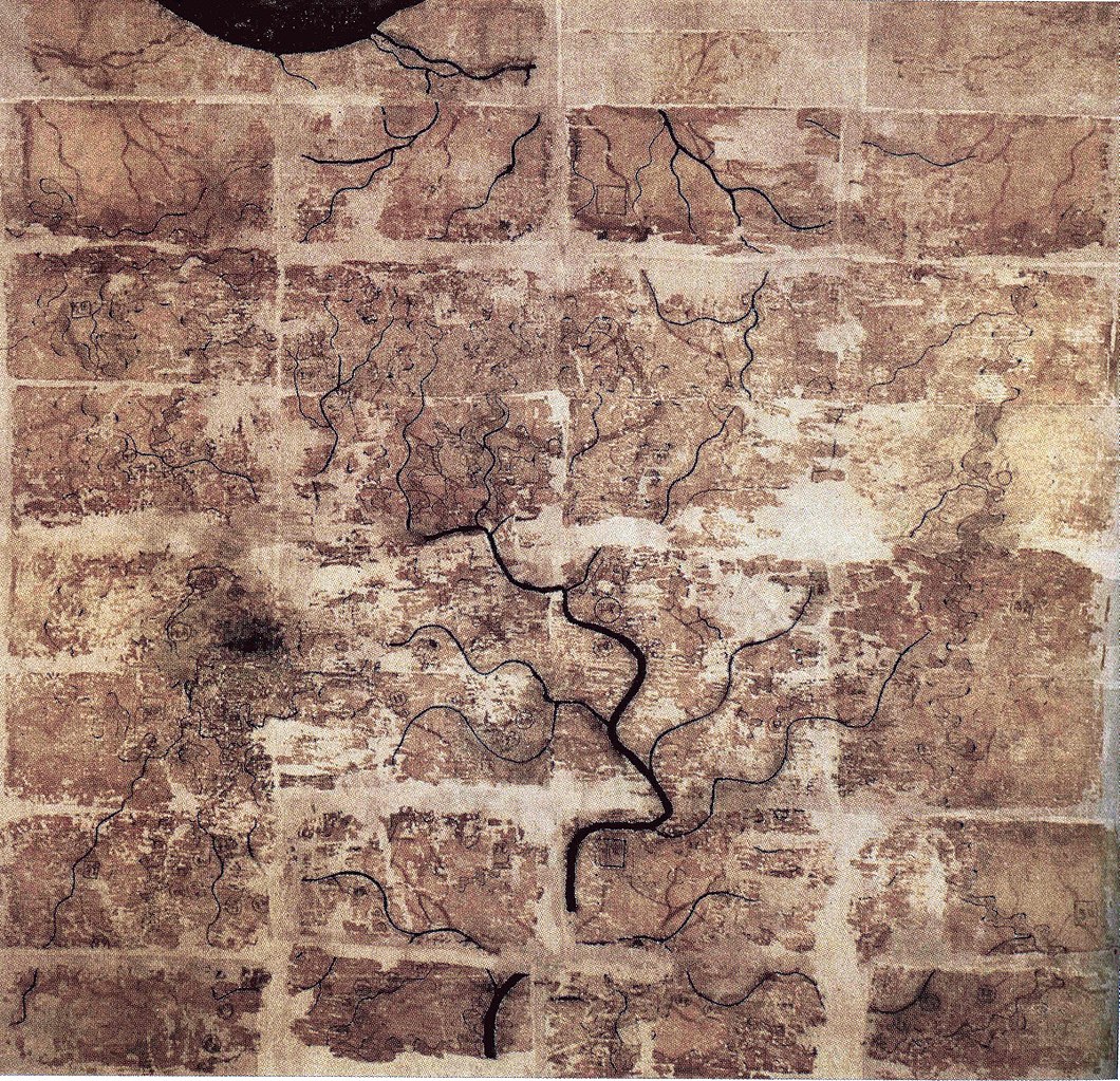
| ការពិពណ៌នា | A Chinese topographic map (with the south positioned at the top) from Mawangdui tomb 3; dated to the early Western Han period (183–168 BC); length is 96 cm; width is 96 cm; the map is made of ink on silk. It is now housed in the Hunan Provincial Museum, Changsha. The map depicts a large territory in southern China spanning from the imperial fiefdom of Changsha (a semi-autonomous kingdom within the Han Empire, now modern-day Hunan) to the independent and sometimes hostile Kingdom of Nanyue in what is now modern-day Guangdong and northern Vietnam. |
| កាលបរិច្ឆេទ | 2nd century BC (anywhere from 183 to 168 BC) |
| ប្រភព | Scanned from Barbieri-Low, Anthony J. (2007). Artisans in Early Imperial China. Seattle and London: University of Washington Press. ISBN 0295987138. Page 174. |
| អ្នកនិពន្ធ | Anonymous ancient Chinese cartographer |
| ទំរង់ផ្សេងទៀត | Derivative works of this file: Cypraea mappa map comparison.jpg |
ការដាក់អាជ្ញាប័ណ្ណ
|
This is a faithful photographic reproduction of a two-dimensional, public domain work of art. The work of art itself is in the public domain for the following reason:
The official position taken by the Wikimedia Foundation is that "faithful reproductions of two-dimensional public domain works of art are public domain".
This photographic reproduction is therefore also considered to be in the public domain in the United States. In other jurisdictions, re-use of this content may be restricted; see Reuse of PD-Art photographs for details. | ||||
ប្រវត្តិឯកសារ
ចុចលើម៉ោងនិងកាលបរិច្ឆេទដើម្បីមើលឯកសារដែលបានផ្ទុកឡើងនៅពេលនោះ។
| ម៉ោងនិងកាលបរិច្ឆេទ | កូនរូបភាព | វិមាត្រ | អ្នកប្រើប្រាស់ | យោបល់ | |
|---|---|---|---|---|---|
| បច្ចុប្បន្ន | ម៉ោង២២:៥៨ ថ្ងៃព្រហស្បតិ៍ ទី១០ ខែឧសភា ឆ្នាំ២០១៨ | | ៣៦៧៥ × ៣៥៤៩ (៣.០៧មេកាបៃ) | Soerfm | Brightness, color, crop. |
| ម៉ោង២២:១០ ថ្ងៃច័ន្ទ ទី២៧ ខែមេសា ឆ្នាំ២០០៩ |  | ៣៦៧៥ × ៣៥៤៩ (២.៨៩មេកាបៃ) | PericlesofAthens | {{Information |Description=A Chinese topographic map (with the south positioned at the top) from Mawangdui tomb 3; dated to the early Western Han period (183–168 BC); length is 96 cm; width is 96 cm; the map is made of ink on silk. It is now housed |
បម្រើបម្រាស់ឯកសារ
ទំព័រ ខាងក្រោមប្រើប្រាស់ឯកសារនេះ ៖
បម្រើបម្រាស់ឯកសារជាសាកល
វីគីដទៃទៀតដូចខាងក្រោមនេះប្រើប្រាស់ឯកសារនេះ៖
- ការប្រើប្រាស់នៅក្នុង als.wikipedia.org
- ការប្រើប្រាស់នៅក្នុង ca.wikipedia.org
- ការប្រើប្រាស់នៅក្នុង de.wikipedia.org
- ការប្រើប្រាស់នៅក្នុង en.wikipedia.org
- ការប្រើប្រាស់នៅក្នុង es.wikipedia.org
- ការប្រើប្រាស់នៅក្នុង fi.wikipedia.org
- ការប្រើប្រាស់នៅក្នុង fr.wikipedia.org
- ការប្រើប្រាស់នៅក្នុង hr.wikipedia.org
- ការប្រើប្រាស់នៅក្នុង id.wikipedia.org
- ការប្រើប្រាស់នៅក្នុង it.wikipedia.org
- ការប្រើប្រាស់នៅក្នុង ja.wikipedia.org
- ការប្រើប្រាស់នៅក្នុង ko.wikipedia.org
- ការប្រើប្រាស់នៅក្នុង mwl.wikipedia.org
- ការប្រើប្រាស់នៅក្នុង nl.wikipedia.org
- ការប្រើប្រាស់នៅក្នុង pl.wikipedia.org
- ការប្រើប្រាស់នៅក្នុង pnb.wikipedia.org
- ការប្រើប្រាស់នៅក្នុង pt.wikipedia.org
- ការប្រើប្រាស់នៅក្នុង ro.wikipedia.org
- ការប្រើប្រាស់នៅក្នុង ru.wikipedia.org
View more global usage of this file.