ឯកសារ:Xinjiang Internment Map, US-Aus Gov Assessment.jpg
ទំហំរបស់ការមើលមុននេះ: ៨០០ × ៤៩៥ ភីកសែ។ ភាពម៉ត់ផ្សេងទៀត៖ ៣២០ × ១៩៨ ភីកសែ | ៦៤០ × ៣៩៦ ភីកសែ | ១០២៤ × ៦៣៤ ភីកសែ | ១២៨០ × ៧៩២ ភីកសែ | ២០៤៨ × ១២៦៧ ភីកសែ។
រូបភាពដើម (២០៤៨ × ១២៦៧ ភីកសែល ទំហំឯកសារ៖ ១៥០គីឡូបៃ ប្រភេទ MIME៖ image/jpeg)
ចំណារពន្យល់
| ការពិពណ៌នា |
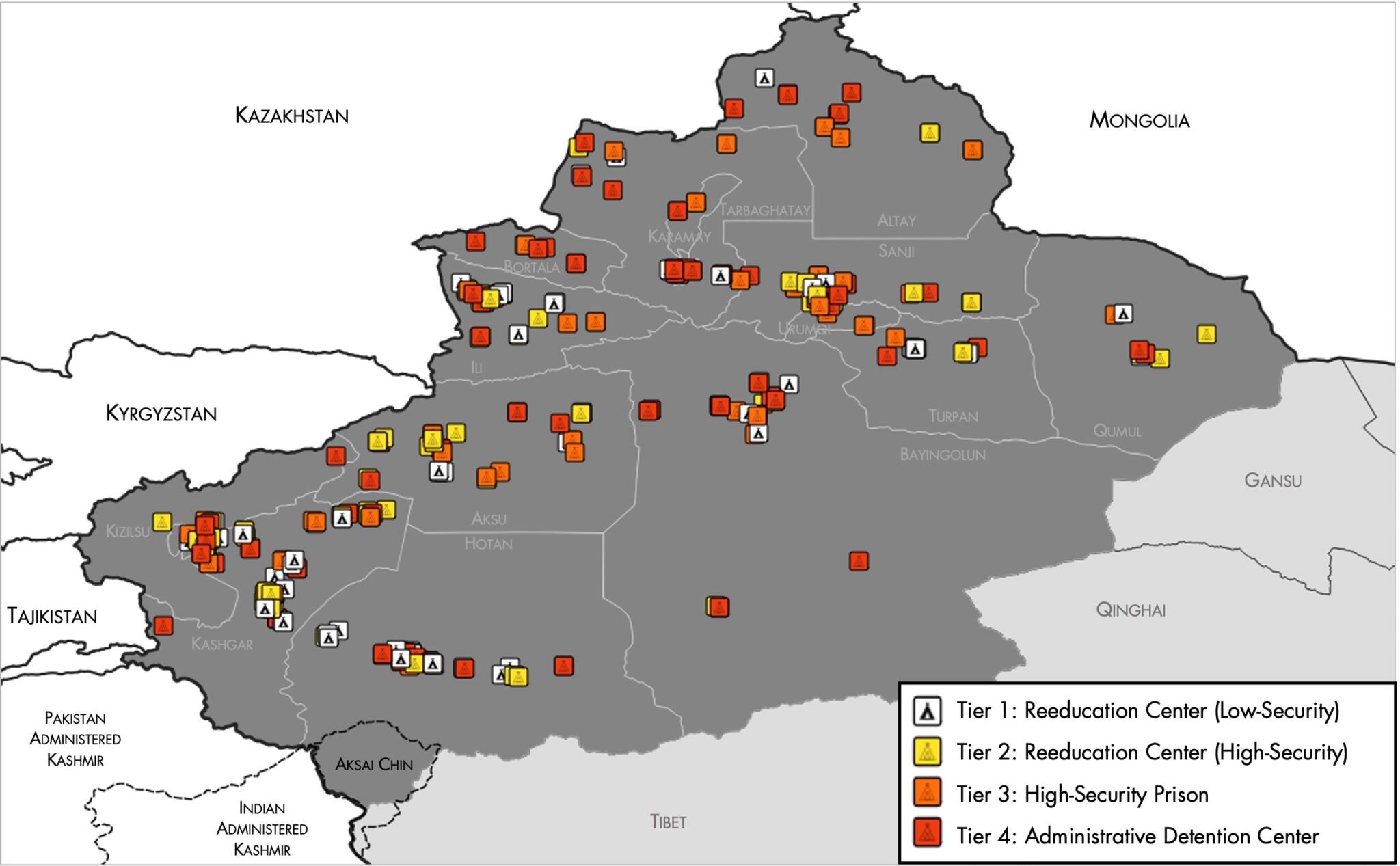
English: Map of the Xinjiang Internment Camps created by the RAND Corporation based on data collected by the US National Geospatial Intelligence Agency and the Australian Strategic Policy Institute. Open source here. |
||||||||
| កាលបរិច្ឆេទ | |||||||||
| ប្រភព | https://www.tearline.mil/public_page/xinjiang-nighttime-1/ | ||||||||
| អ្នកនិពន្ធ | National Geospatial Intelligence Agency, using data from the Australian Strategic Policy Institute, and administrative boundaries from GADM. | ||||||||
| ការអនុញ្ញាត (ប្រើឯកសារនេះឡើងវិញ) |
|


ប្រវត្តិឯកសារ
ចុចលើម៉ោងនិងកាលបរិច្ឆេទដើម្បីមើលឯកសារដែលបានផ្ទុកឡើងនៅពេលនោះ។
| ម៉ោងនិងកាលបរិច្ឆេទ | កូនរូបភាព | វិមាត្រ | អ្នកប្រើប្រាស់ | យោបល់ | |
|---|---|---|---|---|---|
| បច្ចុប្បន្ន | ម៉ោង០៥:០៥ ថ្ងៃអាទិត្យ ទី០២ ខែឧសភា ឆ្នាំ២០២១ | | ២០៤៨ × ១២៦៧ (១៥០គីឡូបៃ) | Abovfold | Uploaded a work by {{w|National Geospatial Intelligence Agency}}, using data from the {{w|Australian Strategic Policy Institute}}, and administrative boundaries from {{w|GADM}}. from https://www.tearline.mil/public_page/xinjiang-nighttime-1/ with UploadWizard |
បម្រើបម្រាស់ឯកសារ
ទំព័រ ខាងក្រោមប្រើប្រាស់ឯកសារនេះ ៖
បម្រើបម្រាស់ឯកសារជាសាកល
វីគីដទៃទៀតដូចខាងក្រោមនេះប្រើប្រាស់ឯកសារនេះ៖
- ការប្រើប្រាស់នៅក្នុង ba.wikipedia.org
- ការប្រើប្រាស់នៅក្នុង br.wikipedia.org
- ការប្រើប្រាស់នៅក្នុង cs.wikipedia.org
- ការប្រើប្រាស់នៅក្នុង de.wikipedia.org
- ការប្រើប្រាស់នៅក្នុង el.wikipedia.org
- ការប្រើប្រាស់នៅក្នុង en.wikipedia.org
- ការប្រើប្រាស់នៅក្នុង es.wikipedia.org
- ការប្រើប្រាស់នៅក្នុង fi.wikipedia.org
- ការប្រើប្រាស់នៅក្នុង fr.wikipedia.org
- ការប្រើប្រាស់នៅក្នុង ga.wikipedia.org
- ការប្រើប្រាស់នៅក្នុង he.wikipedia.org
- ការប្រើប្រាស់នៅក្នុង nl.wikipedia.org
- ការប្រើប្រាស់នៅក្នុង or.wikipedia.org
- ការប្រើប្រាស់នៅក្នុង pl.wikipedia.org
- ការប្រើប្រាស់នៅក្នុង pt.wikipedia.org
- ការប្រើប្រាស់នៅក្នុង ru.wikinews.org
- ការប្រើប្រាស់នៅក្នុង sv.wikipedia.org
- ការប្រើប្រាស់នៅក្នុង szl.wikipedia.org
- ការប្រើប្រាស់នៅក្នុង tr.wikipedia.org
- ការប្រើប្រាស់នៅក្នុង www.wikidata.org