ខេត្តហាយ៉ាង
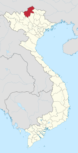
ខេត្តហាយ៉ាង ( Vietnamese: [hàː jāːŋ] ( </img> ) គឺជា ខេត្តមួយនៅ ភូមិភាគឦសាន នៃ ប្រទេសវៀតណាម ។ [៣] វាមានទីតាំងនៅភាគខាងជើងឆ្ងាយនៃប្រទេស ហើយមានចំណុចខាងជើងបំផុតរបស់ប្រទេសវៀតណាម។ ព្រំប្រទល់របស់ខេត្តមាន 270 គីឡូម៉ែត្រ ជាប់ព្រំដែន ជាមួយ ខេត្តយូណាន ភាគខាងត្បូងប្រទេសចិន ហើយដូច្នេះត្រូវបានគេស្គាល់ថាជាព្រំដែនចុងក្រោយរបស់វៀតណាម។ វាគ្របដណ្តប់លើផ្ទៃដី 7,929.48 square kilometres (3,061.6 sq mi) រួមមានទីក្រុង 1 និងស្រុកជនបទចំនួន 10 ដែលមានប្រជាជនជាង 850 ពាន់នាក់គិតត្រឹមឆ្នាំ 2019 ។
| Hà Giang province Tỉnh Hà Giang | |
|---|---|
| ខេត្ត | |
| [[File:|250px|none|alt=|Mã Pí Lèng Pass • Farm Nông - Lâm • Paddy field in Hà Giang • Museum Hà Giang • River Lô • Tam Sơn Mountain • Quản Bạ Mountain • Dong Van Karst Plateau Geopark • Mansion SaPhin • Đồng Văn Temple]]Mã Pí Lèng Pass • Farm Nông - Lâm • Paddy field in Hà Giang • Museum Hà Giang • River Lô • Tam Sơn Mountain • Quản Bạ Mountain • Dong Van Karst Plateau Geopark • Mansion SaPhin • Đồng Văn Temple | |
 | |
[[File: |250px|none|alt=|Location of Hà Giang province]] |250px|none|alt=|Location of Hà Giang province]] | |
| ប្រទេស | |
| Region | Northeast |
| Capital | Hà Giang |
| Subdivision | 1 city, 10 rural districts |
| រដ្ឋាភិបាល | |
| • ប្រភេទ | ខេត្ត |
| • Body | Hà Giang Provincial People's Council |
| • Chairman of People's Council | ថាវ ហុង សឺន |
| ផ្ទៃក្រឡា[១] | |
| • ខេត្ត | ៧៩២៩.៥ គម2 (៣០៦១.៦ ម៉ាយ ការ) |
| ប្រជាជន (2021)[២] | |
| • ខេត្ត | ៨៥៨,៤៦៥ |
| • សន្ទភាព | ០.១១/km2 (០.២៨/sq mi) |
| • Urban | ១៣៨,២១៤ |
| Ethnic groups[២] | |
| • Mông | 34.25% |
| Area codes | 219 |
| ក្រមអ.ម.អ. ៣១៦៦ | VN-03 |
| គេហទំព័រ | hagiang.gov.vn |
ទីរួមខេត្តនេះក៏ត្រូវបានគេហៅផងដែរថា ហាយ៉ាង ត្រូវបានតភ្ជាប់ដោយផ្លូវហាយវេ 2 និងមានប្រវែង 320 គីឡូម៉ែត្រពី ទីក្រុងហាណូយ ។ ច្រកព្រំដែន ថាញ ធឿយ ចម្ងាយ ២៥ឆ្នាំ គីឡូម៉ែត្រពីទីរួមខេត្ត។ វាជាខេត្តមួយក្នុងចំណោមខេត្តក្រីក្របំផុតរបស់វៀតណាម ដោយសារវាមានសណ្ឋានដីភ្នំដែលមានសក្តានុពលតិចតួចបំផុតសម្រាប់ការអភិវឌ្ឍន៍កសិកម្ម។ [៤] [៥] [៦] [៧]
ឯកសារយោង
កែប្រែ- ↑ "Phê duyệt và công bố kết quả thống kê diện tích đất đai của cả nước năm 2018" (ជាVietnamese). Act No. 2908/QĐ-BTNMT of Error: the
dateoryearparameters are either empty or in an invalid format, please use a valid year foryear, and use DMY, MDY, MY, or Y date formats fordate. Ministry of Natural Resources and Environment (Vietnam). http://www.monre.gov.vn/VanBan/Lists/VanBanChiDao/Attachments/2299/QD%202908.rar. - the data in the report are in hectares, rounded to integers - ↑ ២,០ ២,១ General Statistics Office of Vietnam (2019). "Completed Results of the 2019 Viet Nam Population and Housing Census". Statistical Publishing House (Vietnam). ល.ស.ប.អ. 978-604-75-1532-5. https://www.gso.gov.vn/wp-content/uploads/2019/12/Ket-qua-toan-bo-Tong-dieu-tra-dan-so-va-nha-o-2019.pdf.
- ↑ Tim Doling North East VietNam: mountains and ethnic minorities - Page 101 2000 "With its current population of around 536,000, Hà Giang province is the northernmost province of Việt Nam, covering a total land area of 7,831 square kilometres and sharing a 274-kilometre border with China."
- ↑ Footprint Vietnam. Footprint Travel Guides. https://books.google.com/books?id=0FKCuR0i0SMC&pg=PA127។ បានយកមក 2010-07-14.
- ↑ Vietnam. Lonely Planet. https://books.google.com/books?id=ZqOLmYD-0l4C&pg=PA186។ បានយកមក 2010-08-29.
- ↑ Vietnam dawn of a new market. Palgrave Macmillan. https://books.google.com/books?id=-Rx9Qs7egH8C&pg=PA156។ បានយកមក 2010-07-14.
- ↑ Let's Go Vietnam. Macmillan. https://books.google.com/books?id=_cH1JFMpEq0C&pg=PA206។ បានយកមក 2010-07-14.


