ឯកសារ:Ph Territorial Map.png

ទំហំរបស់ការមើលមុននេះ: ៥៨៤ × ៦០០ ភីកសែ។ ភាពម៉ត់ផ្សេងទៀត៖ ២៣៤ × ២៤០ ភីកសែ | ៤៦៧ × ៤៨០ ភីកសែ | ៧៤៨ × ៧៦៨ ភីកសែ | ៩៩៧ × ១០២៤ ភីកសែ | ១៨២៧ × ១៨៧៧ ភីកសែ។
រូបភាពដើម (១៨២៧ × ១៨៧៧ ភីកសែល ទំហំឯកសារ៖ ៦១២គីឡូបៃ ប្រភេទ MIME៖ image/png)

|
រូបភាព mapនេះ គួរតែបង្កើតឡើងវិញដោយប្រើក្រាភិកវ៉ិចទ័រ ដែលជាប្រភេទហ្វាល់ SVG ។ ការបង្កើតរូបភាពជាហ្វាល់ SVG ផ្តល់នូវអត្ថប្រយោជន៍ជាច្រើន។ ចំពោះព័ត៌មានបន្ថែម សូមមើល Commons:Media for cleanup ។ ប្រសិនបើទំរង់ SVG នៃរូបភាពនេះត្រូវបានបង្កើតរួចរាល់ហើយ សូមអាប់ឡូដវា។ បន្ទាប់ពីអាប់ឡូដជាទំរង់ SVG សូមជំនួសទំព័រគំរូនេះដោយ {{vector version available|ឈ្មោះរូបភាពថ្មី.svg}} ។
|
ចំណារពន្យល់
| ការពិពណ៌នា |
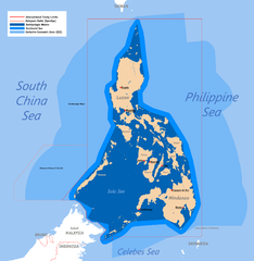
English: Territorial map claimed by the Philippines, showing internal waters, territorial sea, international treaty limits and exclusive economic zone. |
| កាលបរិច្ឆេទ | ២៥ ខែមិថុនា ២០០៧ (original upload) |
| ប្រភព | English Wikipedia (log) |
| អ្នកនិពន្ធ | Roel Balingit (username: Namayan); addition of Benham Rise and Indo-PH EEZs: Ervin Malicdem (schadow1) |
ការដាក់អាជ្ញាប័ណ្ណ
Roel Balingit (username: Namayan), the copyright holder of this work, hereby publishes it under the following licenses:

|
រូបភាពនៃទំព័រនេះជាកម្មសិទ្ធិរបស់GNU Free Documentation License។ Version 1.2 ឬក៏ខ្ពស់ជាងនេះត្រូវបានឧបត្ថមគាំទ្រដោយ មូលនិធិសូហ្វវែរដោយឥតគិតថ្លៃ (Free Software Foundation) ដែលមិនមានផ្នែកណាមួយរបស់ប្រភពដើមរួមទាំងអក្សរនៅលើគំរបមុខនិងខ្នង ត្រូវបានផ្លាស់ប្តូរទេ។ ចំពោះផ្នែកដែលមិនអាចផ្លាស់ប្តូរបាន សូមមើលGNU Free Documentation License។ |
ឯកសារនេះជាប់អាជ្ញាបណ្ឌCreative Commons Attribution 2.5 Generic។
ភាពជាម្ចាស់កម្មសិទ្ធ: Roel Balingit (username: Namayan)
- អ្នកមានសិទ្ធិ៖
- ចែកចាយ – ថតចំលងនិងចែកចាយស្នាដៃនេះ
- កែច្នៃ – កែច្នៃយកទៅប្រើ
- ក្រោមលក្ខខណ្ឌដូចតទៅនេះ៖
- ភាពជាម្ចាស់កម្មសិទ្ធ – You must give appropriate credit, provide a link to the license, and indicate if changes were made. You may do so in any reasonable manner, but not in any way that suggests the licensor endorses you or your use.
You may select the license of your choice.
ប្រវត្តិឯកសារ
ចុចលើម៉ោងនិងកាលបរិច្ឆេទដើម្បីមើលឯកសារដែលបានផ្ទុកឡើងនៅពេលនោះ។
| ម៉ោងនិងកាលបរិច្ឆេទ | កូនរូបភាព | វិមាត្រ | អ្នកប្រើប្រាស់ | យោបល់ | |
|---|---|---|---|---|---|
| បច្ចុប្បន្ន | ម៉ោង០៥:៥៨ ថ្ងៃអាទិត្យ ទី១៩ ខែកក្កដា ឆ្នាំ២០១៥ | | ១៨២៧ × ១៨៧៧ (៦១២គីឡូបៃ) | Schadow1 | Extending EEZ boundaries to include Benham Rise Extended EEZ and Philippines-Indonesia EEZ Delimitation Agreement |
| ម៉ោង១១:៣៣ ថ្ងៃអង្គារ ទី០៨ ខែឧសភា ឆ្នាំ២០១២ |  | ១៨២៧ × ១៧៩០ (៥៣៥គីឡូបៃ) | Sky Harbor | Reverted to version as of 16:54, 28 August 2009. The name "West Philippine Sea" is a neologism and is not neutral. | |
| ម៉ោង០៨:១៣ ថ្ងៃសុក្រ ទី០៤ ខែឧសភា ឆ្នាំ២០១២ |  | ៦១២ × ៦០០ (១២៩គីឡូបៃ) | Jeromesandilanico | Change of name as West Philippine Sea as used to describe the Philippines official claim as used by the Philippine Government and Media. | |
| ម៉ោង១៦:៥៤ ថ្ងៃសុក្រ ទី២៨ ខែសីហា ឆ្នាំ២០០៩ |  | ១៨២៧ × ១៧៩០ (៥៣៥គីឡូបៃ) | Mormegil | {{Information |Description= {{en|Territorial map of the Philippines, showing internal waters, territorial sea, international treaty limits and exclusive economic zone.}} |Source=English Wikipedia |Date={{date|2007-0 |
បម្រើបម្រាស់ឯកសារ
ទំព័រ ខាងក្រោមប្រើប្រាស់ឯកសារនេះ ៖
បម្រើបម្រាស់ឯកសារជាសាកល
វីគីដទៃទៀតដូចខាងក្រោមនេះប្រើប្រាស់ឯកសារនេះ៖
- ការប្រើប្រាស់នៅក្នុង af.wikipedia.org
- ការប្រើប្រាស់នៅក្នុង bn.wikipedia.org
- ការប្រើប្រាស់នៅក្នុង cs.wikipedia.org
- ការប្រើប្រាស់នៅក្នុង de.wikipedia.org
- ការប្រើប្រាស់នៅក្នុង en.wikipedia.org
- Scarborough Shoal
- User:Namayan
- Philippines and the Spratly Islands
- Wikipedia talk:Tambayan Philippines/Archive 16
- Spratly Islands dispute
- Wikipedia:Graphics Lab/Map workshop/Archive/Apr 2013
- Wikipedia:Graphics Lab/Map workshop/Archive/May 2014
- Baselines of the Philippines
- Borders of the Philippines
- User:TagaSanPedroAko/Original contents of Presidency of Rodrigo Duterte
- User:Jose Edmundo Dayot/PIL Module 4
- ការប្រើប្រាស់នៅក្នុង fr.wikipedia.org
- ការប្រើប្រាស់នៅក្នុង gl.wikipedia.org
- ការប្រើប្រាស់នៅក្នុង he.wikipedia.org
- ការប្រើប្រាស់នៅក្នុង he.wiktionary.org
- ការប្រើប្រាស់នៅក្នុង ilo.wikipedia.org
- ការប្រើប្រាស់នៅក្នុង io.wikipedia.org
- ការប្រើប្រាស់នៅក្នុង it.wikipedia.org
- ការប្រើប្រាស់នៅក្នុង ja.wikipedia.org
- ការប្រើប្រាស់នៅក្នុង ka.wikipedia.org
- ការប្រើប្រាស់នៅក្នុង kn.wikipedia.org
- ការប្រើប្រាស់នៅក្នុង mdf.wikipedia.org
- ការប្រើប្រាស់នៅក្នុង pa.wikipedia.org
- ការប្រើប្រាស់នៅក្នុង pl.wikipedia.org
- ការប្រើប្រាស់នៅក្នុង pnb.wikipedia.org
- ការប្រើប្រាស់នៅក្នុង sk.wikipedia.org
- ការប្រើប្រាស់នៅក្នុង th.wikipedia.org
- ការប្រើប្រាស់នៅក្នុង tl.wikipedia.org
- ការប្រើប្រាស់នៅក្នុង uk.wikipedia.org
View more global usage of this file.